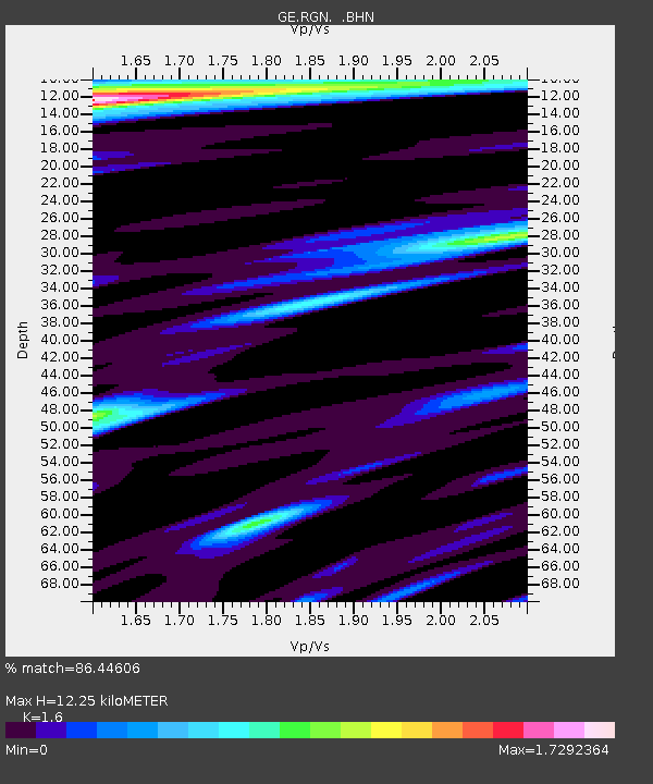
RGN GRSN/GEOFON Station Ruegen, Germany - Earthquake Result Viewer

Earthquake location: Kodiak Island Region, Alaska
Earthquake latitude/longitude: 56.4/-152.9
Earthquake time(UTC): 1999/05/07 (127) 14:13:52 GMT
Earthquake Depth: 20 km
Earthquake Magnitude: 5.7 MB, 6.1 MS, 6.4 MW, 5.7 ME
Earthquake Catalog/Contributor: WHDF/NEIC
Network: GE GEOFON
Station: RGN GRSN/GEOFON Station Ruegen, Germany
Lat/Lon: 54.55 N/13.32 E
Elevation: 15 m
Distance: 68.8 deg
Az: 8.534 deg
Baz: 351.863 deg
Ray Param: 0.056028534
Estimated Moho Depth: 12.25 km
Estimated Crust Vp/Vs: 1.60
Assumed Crust Vp: 6.1 km/s
Estimated Crust Vs: 3.812 km/s
Estimated Crust Poisson's Ratio: 0.18
Radial Match: 86.44606 %
Radial Bump: 400
Transverse Match: 74.228714 %
Transverse Bump: 400
SOD ConfigId: 4480
Insert Time: 2010-03-09 05:07:31.277 +0000
GWidth: 2.5
Max Bumps: 400
Tol: 0.001

Signal To Noise

ChannelStoNSTALTA
GE:RGN: :BHN:19990507T14:24:24.102004Z2.9102788.280595E-72.8452934E-7
GE:RGN: :BHE:19990507T14:24:24.101028Z0.86877352.8696172E-73.303067E-7
GE:RGN: :BHZ:19990507T14:24:24.101028Z0.9748053.9606502E-74.063018E-7
Arrivals
Ps1.3 SECOND
PpPs5.0 SECOND
PsPs/PpSs6.3 SECOND