You are here: Home > Network List > GE - GEOFON Stations List
> Station RGN GRSN/GEOFON Station Ruegen, Germany > Earthquake Result Viewer
RGN GRSN/GEOFON Station Ruegen, Germany - Earthquake Result Viewer
| Earthquake location: |
Taiwan Region |
| Earthquake latitude/longitude: |
24.3/122.2 |
| Earthquake time(UTC): |
2002/03/31 (090) 06:52:50 GMT |
| Earthquake Depth: |
33 km |
| Earthquake Magnitude: |
6.4 MB, 7.4 MS, 7.1 MW, 7.1 MW |
| Earthquake Catalog/Contributor: |
WHDF/NEIC |
|
| Network: |
GE GEOFON |
| Station: |
RGN GRSN/GEOFON Station Ruegen, Germany |
| Lat/Lon: |
54.55 N/13.32 E |
| Elevation: |
15 m |
|
| Distance: |
80.8 deg |
| Az: |
326.042 deg |
| Baz: |
61.038 deg |
| Ray Param: |
0.048011053 |
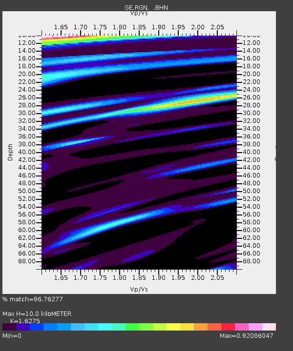
| Estimated Moho Depth: |
10.0 km |
| Estimated Crust Vp/Vs: |
1.63 |
| Assumed Crust Vp: |
6.1 km/s |
| Estimated Crust Vs: |
3.748 km/s |
| Estimated Crust Poisson's Ratio: |
0.20 |
|
| Radial Match: |
96.76277 % |
| Radial Bump: |
400 |
| Transverse Match: |
75.26057 % |
| Transverse Bump: |
400 |
| SOD ConfigId: |
20082 |
| Insert Time: |
2010-03-09 05:07:35.496 +0000 |
| GWidth: |
2.5 |
| Max Bumps: |
400 |
| Tol: |
0.001 |
|

Signal To Noise
| Channel | StoN | STA | LTA |
| GE:RGN: :BHN:20020331T07:04:29.549021Z | 0.97760934 | 4.4359865E-7 | 4.5375862E-7 |
| GE:RGN: :BHE:20020331T07:04:29.549021Z | 1.9142071 | 5.250319E-7 | 2.7428166E-7 |
| GE:RGN: :BHZ:20020331T07:04:29.549021Z | 10.115854 | 2.4917879E-6 | 2.4632502E-7 |
| Arrivals |
| Ps | 1.1 SECOND |
| PpPs | 4.2 SECOND |
| PsPs/PpSs | 5.2 SECOND |


