You are here: Home > Network List > GE - GEOFON Stations List
> Station RGN GRSN/GEOFON Station Ruegen, Germany > Earthquake Result Viewer
RGN GRSN/GEOFON Station Ruegen, Germany - Earthquake Result Viewer
| Earthquake location: |
Northwest Of Kuril Islands |
| Earthquake latitude/longitude: |
47.8/146.2 |
| Earthquake time(UTC): |
2002/11/17 (321) 04:53:53 GMT |
| Earthquake Depth: |
459 km |
| Earthquake Magnitude: |
7.3 MW, 7.3 MW |
| Earthquake Catalog/Contributor: |
WHDF/NEIC |
|
| Network: |
GE GEOFON |
| Station: |
RGN GRSN/GEOFON Station Ruegen, Germany |
| Lat/Lon: |
54.55 N/13.32 E |
| Elevation: |
15 m |
|
| Distance: |
70.5 deg |
| Az: |
333.079 deg |
| Baz: |
31.58 deg |
| Ray Param: |
0.053446967 |
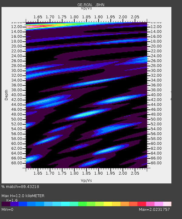
| Estimated Moho Depth: |
12.0 km |
| Estimated Crust Vp/Vs: |
1.60 |
| Assumed Crust Vp: |
6.1 km/s |
| Estimated Crust Vs: |
3.812 km/s |
| Estimated Crust Poisson's Ratio: |
0.18 |
|
| Radial Match: |
89.43218 % |
| Radial Bump: |
400 |
| Transverse Match: |
75.99195 % |
| Transverse Bump: |
400 |
| SOD ConfigId: |
4714 |
| Insert Time: |
2010-03-09 05:07:37.855 +0000 |
| GWidth: |
2.5 |
| Max Bumps: |
400 |
| Tol: |
0.001 |
|

Signal To Noise
| Channel | StoN | STA | LTA |
| GE:RGN: :BHN:20021117T05:03:50.086997Z | 9.683854 | 7.1636664E-6 | 7.3975366E-7 |
| GE:RGN: :BHE:20021117T05:03:50.086021Z | 3.7976248 | 3.3733554E-6 | 8.8828034E-7 |
| GE:RGN: :BHZ:20021117T05:03:50.086021Z | 41.18157 | 2.2597445E-5 | 5.4872714E-7 |
| Arrivals |
| Ps | 1.2 SECOND |
| PpPs | 4.9 SECOND |
| PsPs/PpSs | 6.2 SECOND |


