You are here: Home > Network List > TX - Texas Seismological Network Stations List
> Station WTFS Witchita Falls > Earthquake Result Viewer
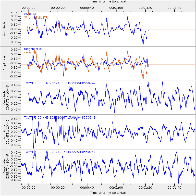
WTFS Witchita Falls - Earthquake Result Viewer
*The percent match for this event was below the threshold and hence no stack was calculated.
| Earthquake location: |
Near East Coast Of Honshu, Japan |
| Earthquake latitude/longitude: |
37.1/141.2 |
| Earthquake time(UTC): |
2017/10/06 (279) 14:56:40 GMT |
| Earthquake Depth: |
47 km |
| Earthquake Magnitude: |
5.4 Mww |
| Earthquake Catalog/Contributor: |
NEIC PDE/us |
|
| Network: |
TX Texas Seismological Network |
| Station: |
WTFS Witchita Falls |
| Lat/Lon: |
33.77 N/98.46 W |
| Elevation: |
277 m |
|
| Distance: |
90.2 deg |
| Az: |
45.969 deg |
| Baz: |
316.366 deg |
| Ray Param: |
$rayparam |
*The percent match for this event was below the threshold and hence was not used in the summary stack. |
|
| Radial Match: |
68.44601 % |
| Radial Bump: |
400 |
| Transverse Match: |
64.321205 % |
| Transverse Bump: |
362 |
| SOD ConfigId: |
2364251 |
| Insert Time: |
2017-10-20 15:00:38.185 +0000 |
| GWidth: |
2.5 |
| Max Bumps: |
400 |
| Tol: |
0.001 |
|
Signal To Noise
| Channel | StoN | STA | LTA |
| TX:WTFS:00:HHZ:20171006T15:09:04.855024Z | 2.5306199 | 2.9533754E-7 | 1.1670562E-7 |
| TX:WTFS:00:HH1:20171006T15:09:04.855024Z | 2.335924 | 2.4362257E-7 | 1.0429389E-7 |
| TX:WTFS:00:HH2:20171006T15:09:04.855024Z | 1.8995697 | 2.2520126E-7 | 1.1855383E-7 |
| Arrivals |
| Ps | |
| PpPs | |
| PsPs/PpSs | |


