You are here: Home > Network List > US - United States National Seismic Network Stations List
> Station DGMT Dagmar, Montana, USA > Earthquake Result Viewer
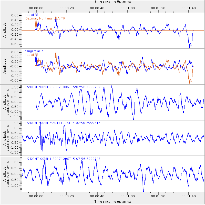
DGMT Dagmar, Montana, USA - Earthquake Result Viewer
*The percent match for this event was below the threshold and hence no stack was calculated.
| Earthquake location: |
Near East Coast Of Honshu, Japan |
| Earthquake latitude/longitude: |
37.1/141.2 |
| Earthquake time(UTC): |
2017/10/06 (279) 14:56:40 GMT |
| Earthquake Depth: |
47 km |
| Earthquake Magnitude: |
5.4 Mww |
| Earthquake Catalog/Contributor: |
NEIC PDE/us |
|
| Network: |
US United States National Seismic Network |
| Station: |
DGMT Dagmar, Montana, USA |
| Lat/Lon: |
48.47 N/104.20 W |
| Elevation: |
0.0 m |
|
| Distance: |
76.9 deg |
| Az: |
38.407 deg |
| Baz: |
311.724 deg |
| Ray Param: |
$rayparam |
*The percent match for this event was below the threshold and hence was not used in the summary stack. |
|
| Radial Match: |
58.374783 % |
| Radial Bump: |
400 |
| Transverse Match: |
55.46101 % |
| Transverse Bump: |
400 |
| SOD ConfigId: |
2364251 |
| Insert Time: |
2017-10-20 15:00:55.037 +0000 |
| GWidth: |
2.5 |
| Max Bumps: |
400 |
| Tol: |
0.001 |
|
Signal To Noise
| Channel | StoN | STA | LTA |
| US:DGMT:00:BHZ:20171006T15:07:56.799971Z | 2.7285728 | 6.945988E-7 | 2.5456487E-7 |
| US:DGMT:00:BH1:20171006T15:07:56.799971Z | 1.0963564 | 4.5427876E-7 | 4.1435317E-7 |
| US:DGMT:00:BH2:20171006T15:07:56.799971Z | 2.2272315 | 9.3020003E-7 | 4.1764855E-7 |
| Arrivals |
| Ps | |
| PpPs | |
| PsPs/PpSs | |


