You are here: Home > Network List > US - United States National Seismic Network Stations List
> Station AMTX Amarillo, Texas, USA > Earthquake Result Viewer
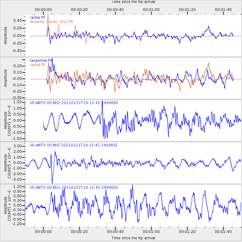
AMTX Amarillo, Texas, USA - Earthquake Result Viewer
*The percent match for this event was below the threshold and hence no stack was calculated.
| Earthquake location: |
Guyana |
| Earthquake latitude/longitude: |
2.6/-59.6 |
| Earthquake time(UTC): |
2021/01/31 (031) 19:05:15 GMT |
| Earthquake Depth: |
9.7 km |
| Earthquake Magnitude: |
5.7 Mww |
| Earthquake Catalog/Contributor: |
NEIC PDE/us |
|
| Network: |
US United States National Seismic Network |
| Station: |
AMTX Amarillo, Texas, USA |
| Lat/Lon: |
34.53 N/101.41 W |
| Elevation: |
1010 m |
|
| Distance: |
50.1 deg |
| Az: |
314.228 deg |
| Baz: |
119.886 deg |
| Ray Param: |
$rayparam |
*The percent match for this event was below the threshold and hence was not used in the summary stack. |
|
| Radial Match: |
55.56425 % |
| Radial Bump: |
400 |
| Transverse Match: |
57.691887 % |
| Transverse Bump: |
400 |
| SOD ConfigId: |
23341671 |
| Insert Time: |
2021-02-14 20:29:46.025 +0000 |
| GWidth: |
2.5 |
| Max Bumps: |
400 |
| Tol: |
0.001 |
|
Signal To Noise
| Channel | StoN | STA | LTA |
| US:AMTX:00:BHZ:20210131T19:13:42.349989Z | 2.8898332 | 7.929814E-7 | 2.7440385E-7 |
| US:AMTX:00:BH1:20210131T19:13:42.349989Z | 2.181091 | 3.8685195E-7 | 1.7736626E-7 |
| US:AMTX:00:BH2:20210131T19:13:42.349989Z | 0.6334762 | 2.717753E-7 | 4.290221E-7 |
| Arrivals |
| Ps | |
| PpPs | |
| PsPs/PpSs | |


