You are here: Home > Network List > WY - Yellowstone Wyoming Seismic Network Stations List
> Station YHR Hawk's Rest, WY, USA > Earthquake Result Viewer
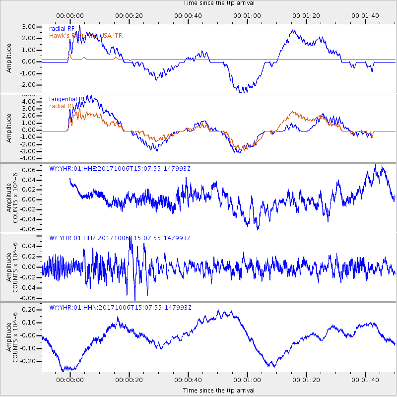
YHR Hawk's Rest, WY, USA - Earthquake Result Viewer
*The percent match for this event was below the threshold and hence no stack was calculated.
| Earthquake location: |
Near East Coast Of Honshu, Japan |
| Earthquake latitude/longitude: |
37.1/141.2 |
| Earthquake time(UTC): |
2017/10/06 (279) 14:56:40 GMT |
| Earthquake Depth: |
47 km |
| Earthquake Magnitude: |
5.4 Mww |
| Earthquake Catalog/Contributor: |
NEIC PDE/us |
|
| Network: |
WY Yellowstone Wyoming Seismic Network |
| Station: |
YHR Hawk's Rest, WY, USA |
| Lat/Lon: |
44.11 N/110.08 W |
| Elevation: |
2976 m |
|
| Distance: |
76.6 deg |
| Az: |
44.536 deg |
| Baz: |
308.885 deg |
| Ray Param: |
$rayparam |
*The percent match for this event was below the threshold and hence was not used in the summary stack. |
|
| Radial Match: |
29.790575 % |
| Radial Bump: |
400 |
| Transverse Match: |
31.44388 % |
| Transverse Bump: |
400 |
| SOD ConfigId: |
2364251 |
| Insert Time: |
2017-10-20 15:02:10.640 +0000 |
| GWidth: |
2.5 |
| Max Bumps: |
400 |
| Tol: |
0.001 |
|
Signal To Noise
| Channel | StoN | STA | LTA |
| WY:YHR:01:HHZ:20171006T15:07:55.147993Z | 1.3604957 | 1.1951857E-8 | 8.784928E-9 |
| WY:YHR:01:HHN:20171006T15:07:55.147993Z | 2.4891431 | 3.596697E-7 | 1.444954E-7 |
| WY:YHR:01:HHE:20171006T15:07:55.147993Z | 1.2990528 | 1.5710542E-8 | 1.2093844E-8 |
| Arrivals |
| Ps | |
| PpPs | |
| PsPs/PpSs | |


