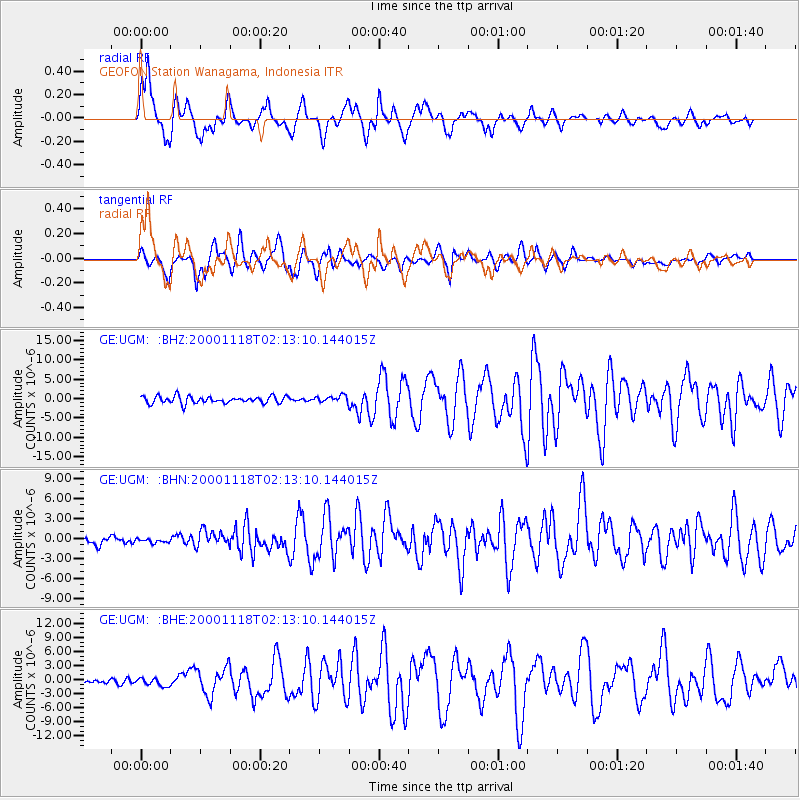
UGM GEOFON Station Wanagama, Indonesia - Earthquake Result Viewer
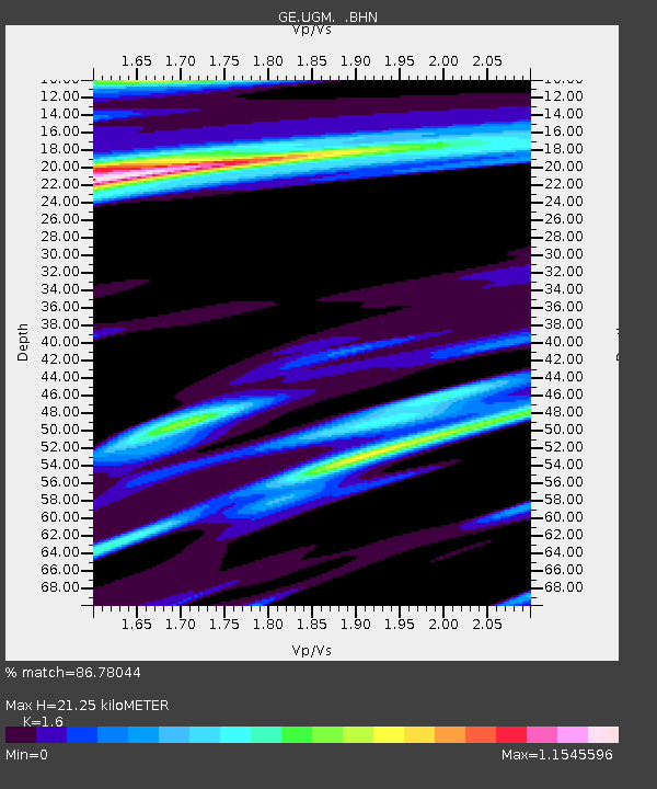
Earthquake location: New Ireland Region, P.N.G.
Earthquake latitude/longitude: -5.1/153.2
Earthquake time(UTC): 2000/11/18 (323) 02:05:48 GMT
Earthquake Depth: 33 km
Earthquake Magnitude: 5.9 MB, 6.6 MS, 6.9 MW, 6.4 ME
Earthquake Catalog/Contributor: WHDF/NEIC
Network: GE GEOFON
Station: UGM GEOFON Station Wanagama, Indonesia
Lat/Lon: 7.91 S/110.52 E
Elevation: 350 m
Distance: 42.5 deg
Az: 263.884 deg
Baz: 88.917 deg
Ray Param: 0.07310017
Estimated Moho Depth: 21.25 km
Estimated Crust Vp/Vs: 1.60
Assumed Crust Vp: 6.343 km/s
Estimated Crust Vs: 3.965 km/s
Estimated Crust Poisson's Ratio: 0.18
Radial Match: 86.78044 %
Radial Bump: 400
Transverse Match: 77.61344 %
Transverse Bump: 400
SOD ConfigId: 3744
Insert Time: 2010-03-09 05:10:09.693 +0000
GWidth: 2.5
Max Bumps: 400
Tol: 0.001

Signal To Noise

ChannelStoNSTALTA
GE:UGM: :BHN:20001118T02:13:10.144015Z0.54384533.579596E-76.582012E-7
GE:UGM: :BHE:20001118T02:13:10.144015Z1.2687778.483622E-76.686456E-7
GE:UGM: :BHZ:20001118T02:13:10.144015Z0.92137318.375159E-79.089867E-7
Arrivals
Ps2.2 SECOND
PpPs8.1 SECOND
PsPs/PpSs10 SECOND