You are here: Home > Network List > TA - USArray Transportable Network (new EarthScope stations) Stations List
> Station E20K Nigu River, AK, USA > Earthquake Result Viewer
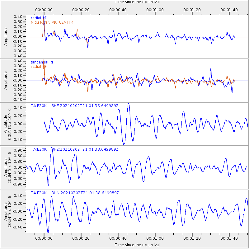
E20K Nigu River, AK, USA - Earthquake Result Viewer
*The percent match for this event was below the threshold and hence no stack was calculated.
| Earthquake location: |
Fiji Islands |
| Earthquake latitude/longitude: |
-16.2/177.9 |
| Earthquake time(UTC): |
2021/02/02 (033) 20:49:28 GMT |
| Earthquake Depth: |
10 km |
| Earthquake Magnitude: |
5.8 Mww |
| Earthquake Catalog/Contributor: |
NEIC PDE/us |
|
| Network: |
TA USArray Transportable Network (new EarthScope stations) |
| Station: |
E20K Nigu River, AK, USA |
| Lat/Lon: |
68.26 N/156.19 W |
| Elevation: |
866 m |
|
| Distance: |
86.3 deg |
| Az: |
9.381 deg |
| Baz: |
204.848 deg |
| Ray Param: |
$rayparam |
*The percent match for this event was below the threshold and hence was not used in the summary stack. |
|
| Radial Match: |
61.94479 % |
| Radial Bump: |
397 |
| Transverse Match: |
60.893665 % |
| Transverse Bump: |
400 |
| SOD ConfigId: |
23341671 |
| Insert Time: |
2021-02-16 22:06:28.748 +0000 |
| GWidth: |
2.5 |
| Max Bumps: |
400 |
| Tol: |
0.001 |
|
Signal To Noise
| Channel | StoN | STA | LTA |
| TA:E20K: :BHZ:20210202T21:01:38.649989Z | 3.8509872 | 5.695421E-7 | 1.478951E-7 |
| TA:E20K: :BHN:20210202T21:01:38.649989Z | 2.8472457 | 3.05767E-7 | 1.07390456E-7 |
| TA:E20K: :BHE:20210202T21:01:38.649989Z | 1.793899 | 1.6545675E-7 | 9.223304E-8 |
| Arrivals |
| Ps | |
| PpPs | |
| PsPs/PpSs | |


