You are here: Home > Network List > TA - USArray Transportable Network (new EarthScope stations) Stations List
> Station F26K Sheenjek River, AK, USA > Earthquake Result Viewer
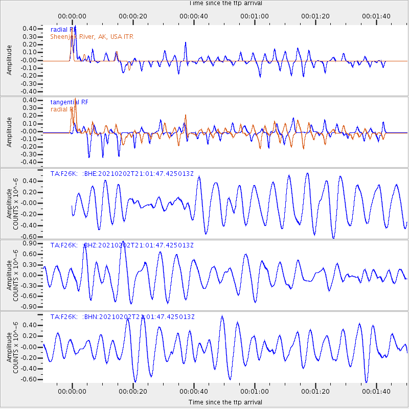
F26K Sheenjek River, AK, USA - Earthquake Result Viewer
*The percent match for this event was below the threshold and hence no stack was calculated.
| Earthquake location: |
Fiji Islands |
| Earthquake latitude/longitude: |
-16.2/177.9 |
| Earthquake time(UTC): |
2021/02/02 (033) 20:49:28 GMT |
| Earthquake Depth: |
10 km |
| Earthquake Magnitude: |
5.8 Mww |
| Earthquake Catalog/Contributor: |
NEIC PDE/us |
|
| Network: |
TA USArray Transportable Network (new EarthScope stations) |
| Station: |
F26K Sheenjek River, AK, USA |
| Lat/Lon: |
67.69 N/144.15 W |
| Elevation: |
683 m |
|
| Distance: |
88.2 deg |
| Az: |
13.578 deg |
| Baz: |
216.21 deg |
| Ray Param: |
$rayparam |
*The percent match for this event was below the threshold and hence was not used in the summary stack. |
|
| Radial Match: |
64.17935 % |
| Radial Bump: |
336 |
| Transverse Match: |
62.370975 % |
| Transverse Bump: |
284 |
| SOD ConfigId: |
23341671 |
| Insert Time: |
2021-02-16 22:06:37.849 +0000 |
| GWidth: |
2.5 |
| Max Bumps: |
400 |
| Tol: |
0.001 |
|
Signal To Noise
| Channel | StoN | STA | LTA |
| TA:F26K: :BHZ:20210202T21:01:47.425013Z | 3.1281638 | 4.0975067E-7 | 1.309876E-7 |
| TA:F26K: :BHN:20210202T21:01:47.425013Z | 0.33992592 | 8.421465E-8 | 2.477441E-7 |
| TA:F26K: :BHE:20210202T21:01:47.425013Z | 0.3394125 | 6.942764E-8 | 2.045524E-7 |
| Arrivals |
| Ps | |
| PpPs | |
| PsPs/PpSs | |


