You are here: Home > Network List > TA - USArray Transportable Network (new EarthScope stations) Stations List
> Station R33M Jennings River, BC, CAN > Earthquake Result Viewer
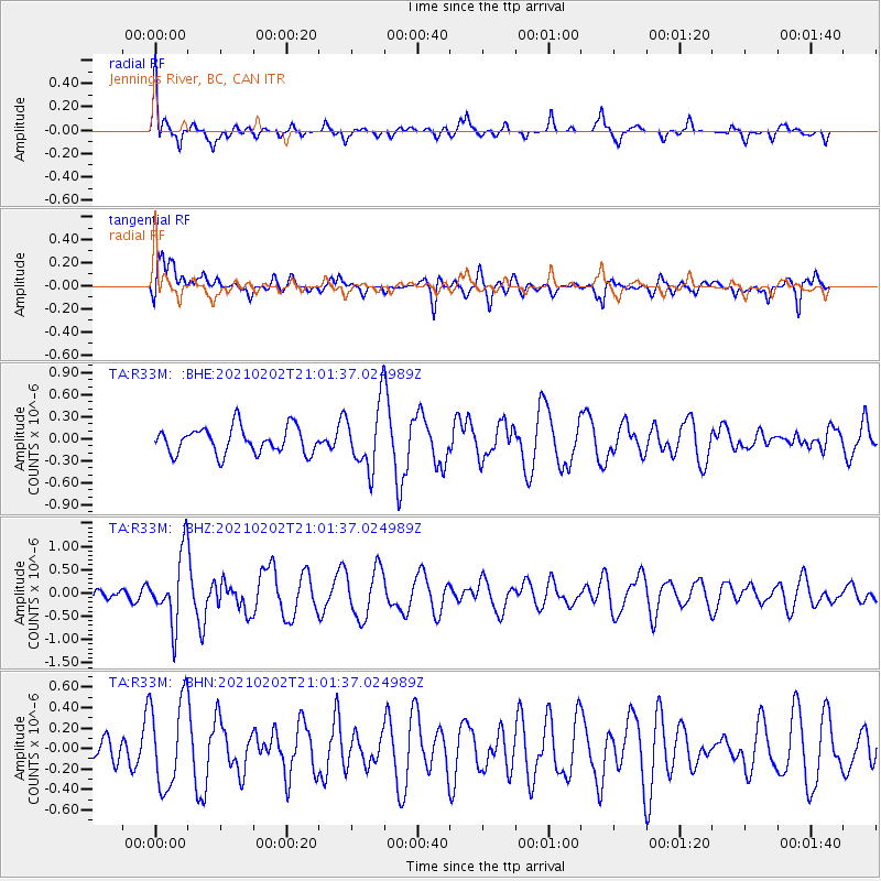
R33M Jennings River, BC, CAN - Earthquake Result Viewer
*The percent match for this event was below the threshold and hence no stack was calculated.
| Earthquake location: |
Fiji Islands |
| Earthquake latitude/longitude: |
-16.2/177.9 |
| Earthquake time(UTC): |
2021/02/02 (033) 20:49:28 GMT |
| Earthquake Depth: |
10 km |
| Earthquake Magnitude: |
5.8 Mww |
| Earthquake Catalog/Contributor: |
NEIC PDE/us |
|
| Network: |
TA USArray Transportable Network (new EarthScope stations) |
| Station: |
R33M Jennings River, BC, CAN |
| Lat/Lon: |
59.39 N/130.97 W |
| Elevation: |
1437 m |
|
| Distance: |
86.0 deg |
| Az: |
23.528 deg |
| Baz: |
228.542 deg |
| Ray Param: |
$rayparam |
*The percent match for this event was below the threshold and hence was not used in the summary stack. |
|
| Radial Match: |
56.908043 % |
| Radial Bump: |
379 |
| Transverse Match: |
54.566242 % |
| Transverse Bump: |
400 |
| SOD ConfigId: |
23341671 |
| Insert Time: |
2021-02-16 22:07:34.386 +0000 |
| GWidth: |
2.5 |
| Max Bumps: |
400 |
| Tol: |
0.001 |
|
Signal To Noise
| Channel | StoN | STA | LTA |
| TA:R33M: :BHZ:20210202T21:01:37.024989Z | 4.290634 | 7.3693286E-7 | 1.7175383E-7 |
| TA:R33M: :BHN:20210202T21:01:37.024989Z | 1.1217707 | 4.3115065E-7 | 3.8434828E-7 |
| TA:R33M: :BHE:20210202T21:01:37.024989Z | 2.4277875 | 4.350315E-7 | 1.7918845E-7 |
| Arrivals |
| Ps | |
| PpPs | |
| PsPs/PpSs | |


