You are here: Home > Network List > IU - Global Seismograph Network (GSN - IRIS/USGS) Stations List
> Station PMG Port Moresby, New Guinea > Earthquake Result Viewer
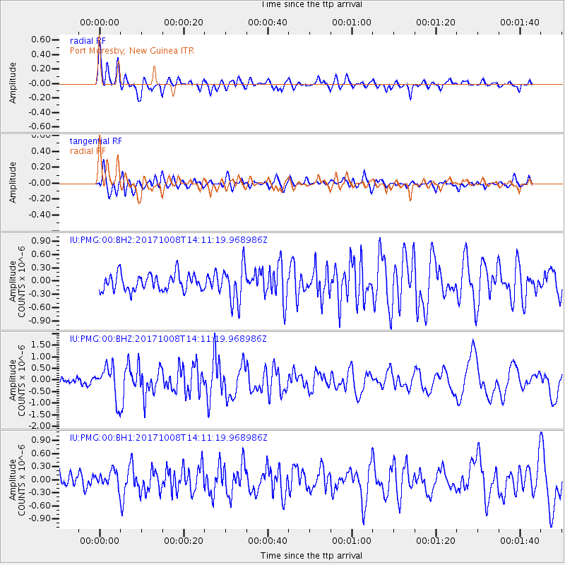
PMG Port Moresby, New Guinea - Earthquake Result Viewer
*The percent match for this event was below the threshold and hence no stack was calculated.
| Earthquake location: |
Tonga Islands |
| Earthquake latitude/longitude: |
-19.0/-175.6 |
| Earthquake time(UTC): |
2017/10/08 (281) 14:04:38 GMT |
| Earthquake Depth: |
10 km |
| Earthquake Magnitude: |
6.1 Mww |
| Earthquake Catalog/Contributor: |
NEIC PDE/us |
|
| Network: |
IU Global Seismograph Network (GSN - IRIS/USGS) |
| Station: |
PMG Port Moresby, New Guinea |
| Lat/Lon: |
9.40 S/147.16 E |
| Elevation: |
90 m |
|
| Distance: |
37.3 deg |
| Az: |
279.557 deg |
| Baz: |
108.999 deg |
| Ray Param: |
$rayparam |
*The percent match for this event was below the threshold and hence was not used in the summary stack. |
|
| Radial Match: |
81.43454 % |
| Radial Bump: |
400 |
| Transverse Match: |
71.925026 % |
| Transverse Bump: |
400 |
| SOD ConfigId: |
2364251 |
| Insert Time: |
2017-10-22 14:12:00.746 +0000 |
| GWidth: |
2.5 |
| Max Bumps: |
400 |
| Tol: |
0.001 |
|
Signal To Noise
| Channel | StoN | STA | LTA |
| IU:PMG:00:BHZ:20171008T14:11:19.968986Z | 6.14843 | 7.18361E-7 | 1.1683649E-7 |
| IU:PMG:00:BH1:20171008T14:11:19.968986Z | 1.0610064 | 1.8788964E-7 | 1.7708624E-7 |
| IU:PMG:00:BH2:20171008T14:11:19.968986Z | 2.301754 | 4.205197E-7 | 1.8269533E-7 |
| Arrivals |
| Ps | |
| PpPs | |
| PsPs/PpSs | |


