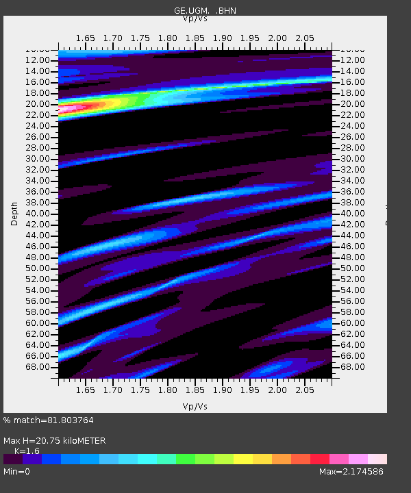
UGM GEOFON Station Wanagama, Indonesia - Earthquake Result Viewer
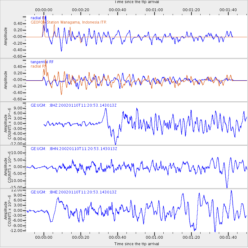
Earthquake location: Near N Coast Of New Guinea, P.N.G.
Earthquake latitude/longitude: -3.2/142.4
Earthquake time(UTC): 2002/01/10 (010) 11:14:56 GMT
Earthquake Depth: 11 km
Earthquake Magnitude: 6.0 MB, 6.6 MS, 6.7 MW, 6.6 MW
Earthquake Catalog/Contributor: WHDF/NEIC
Network: GE GEOFON
Station: UGM GEOFON Station Wanagama, Indonesia
Lat/Lon: 7.91 S/110.52 E
Elevation: 350 m
Distance: 32.1 deg
Az: 260.273 deg
Baz: 83.429 deg
Ray Param: 0.07880018
Estimated Moho Depth: 20.75 km
Estimated Crust Vp/Vs: 1.60
Assumed Crust Vp: 6.343 km/s
Estimated Crust Vs: 3.965 km/s
Estimated Crust Poisson's Ratio: 0.18
Radial Match: 81.803764 %
Radial Bump: 400
Transverse Match: 74.46576 %
Transverse Bump: 400
SOD ConfigId: 20082
Insert Time: 2010-03-09 05:10:31.111 +0000
GWidth: 2.5
Max Bumps: 400
Tol: 0.001

Signal To Noise

ChannelStoNSTALTA
GE:UGM: :BHN:20020110T11:20:53.143013Z0.877229635.635364E-76.4240464E-7
GE:UGM: :BHE:20020110T11:20:53.143013Z7.14690833.3288243E-64.6577125E-7
GE:UGM: :BHZ:20020110T11:20:53.143013Z6.1159334.267141E-66.977089E-7
Arrivals
Ps2.1 SECOND
PpPs7.8 SECOND
PsPs/PpSs9.9 SECOND