You are here: Home > Network List > GE - GEOFON Stations List
> Station UGM GEOFON Station Wanagama, Indonesia > Earthquake Result Viewer
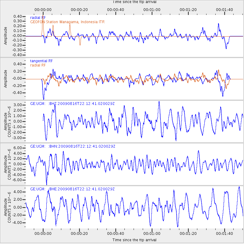
UGM GEOFON Station Wanagama, Indonesia - Earthquake Result Viewer
*The percent match for this event was below the threshold and hence no stack was calculated.
| Earthquake location: |
Fiji Islands Region |
| Earthquake latitude/longitude: |
-17.9/-179.4 |
| Earthquake time(UTC): |
2009/08/16 (228) 22:03:09 GMT |
| Earthquake Depth: |
626 km |
| Earthquake Magnitude: |
5.5 MW, 4.9 MB |
| Earthquake Catalog/Contributor: |
WHDF/NEIC |
|
| Network: |
GE GEOFON |
| Station: |
UGM GEOFON Station Wanagama, Indonesia |
| Lat/Lon: |
7.91 S/110.52 E |
| Elevation: |
350 m |
|
| Distance: |
68.7 deg |
| Az: |
268.347 deg |
| Baz: |
106.13 deg |
| Ray Param: |
$rayparam |
*The percent match for this event was below the threshold and hence was not used in the summary stack. |
|
| Radial Match: |
58.878128 % |
| Radial Bump: |
400 |
| Transverse Match: |
71.55786 % |
| Transverse Bump: |
400 |
| SOD ConfigId: |
2622 |
| Insert Time: |
2010-03-09 05:10:52.527 +0000 |
| GWidth: |
2.5 |
| Max Bumps: |
400 |
| Tol: |
0.001 |
|
Signal To Noise
| Channel | StoN | STA | LTA |
| GE:UGM: :BHN:20090816T22:12:41.020029Z | 1.4442501 | 3.077161E-6 | 2.130629E-6 |
| GE:UGM: :BHE:20090816T22:12:41.020029Z | 1.9808959 | 2.8687818E-6 | 1.4482245E-6 |
| GE:UGM: :BHZ:20090816T22:12:41.020029Z | 0.7653467 | 9.532882E-7 | 1.2455639E-6 |
| Arrivals |
| Ps | |
| PpPs | |
| PsPs/PpSs | |


