You are here: Home > Network List > WY - Yellowstone Wyoming Seismic Network Stations List
> Station YHH Holmes Hill, YNP, WY, USA > Earthquake Result Viewer
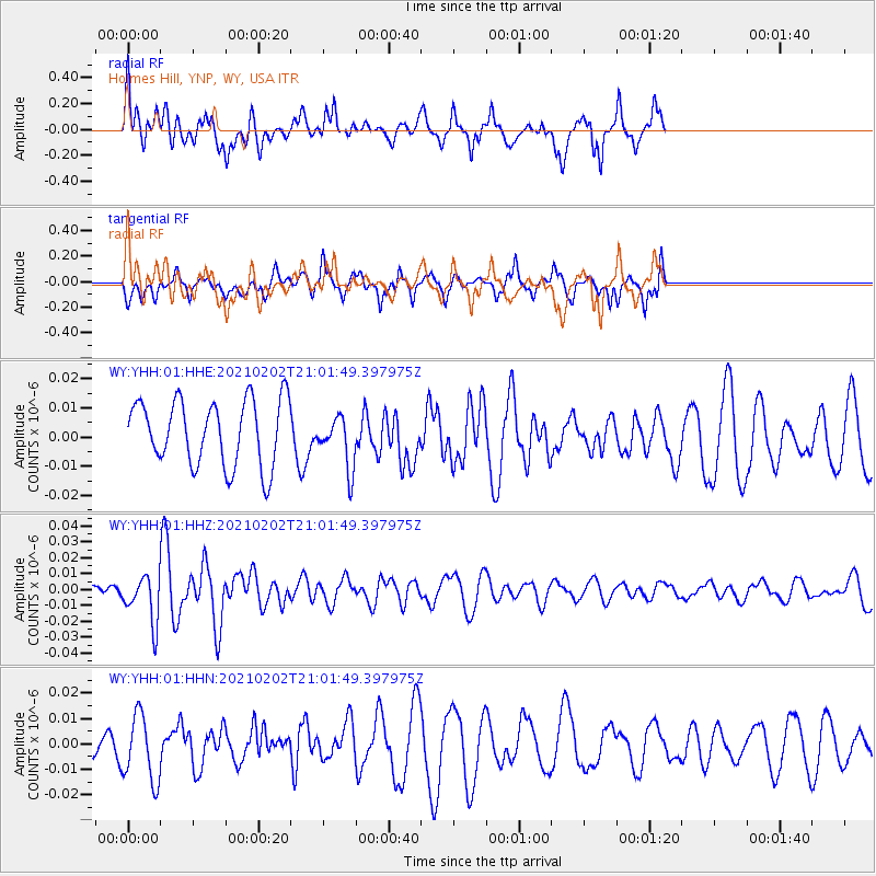
YHH Holmes Hill, YNP, WY, USA - Earthquake Result Viewer
*The percent match for this event was below the threshold and hence no stack was calculated.
| Earthquake location: |
Fiji Islands |
| Earthquake latitude/longitude: |
-16.2/177.9 |
| Earthquake time(UTC): |
2021/02/02 (033) 20:49:28 GMT |
| Earthquake Depth: |
10 km |
| Earthquake Magnitude: |
5.8 Mww |
| Earthquake Catalog/Contributor: |
NEIC PDE/us |
|
| Network: |
WY Yellowstone Wyoming Seismic Network |
| Station: |
YHH Holmes Hill, YNP, WY, USA |
| Lat/Lon: |
44.79 N/110.85 W |
| Elevation: |
2717 m |
|
| Distance: |
88.6 deg |
| Az: |
42.407 deg |
| Baz: |
245.467 deg |
| Ray Param: |
$rayparam |
*The percent match for this event was below the threshold and hence was not used in the summary stack. |
|
| Radial Match: |
71.65724 % |
| Radial Bump: |
400 |
| Transverse Match: |
55.935627 % |
| Transverse Bump: |
396 |
| SOD ConfigId: |
23341671 |
| Insert Time: |
2021-02-16 22:12:00.834 +0000 |
| GWidth: |
2.5 |
| Max Bumps: |
400 |
| Tol: |
0.001 |
|
Signal To Noise
| Channel | StoN | STA | LTA |
| WY:YHH:01:HHZ:20210202T21:01:49.397975Z | 4.5828023 | 1.4582221E-8 | 3.1819443E-9 |
| WY:YHH:01:HHN:20210202T21:01:49.397975Z | 2.8290548 | 1.2991055E-8 | 4.5920125E-9 |
| WY:YHH:01:HHE:20210202T21:01:49.397975Z | 0.80230004 | 8.966894E-9 | 1.1176485E-8 |
| Arrivals |
| Ps | |
| PpPs | |
| PsPs/PpSs | |


