You are here: Home > Network List > US - United States National Seismic Network Stations List
> Station TPNV Topopah Spring, Nevada, USA > Earthquake Result Viewer
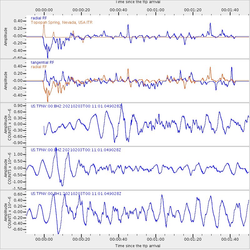
TPNV Topopah Spring, Nevada, USA - Earthquake Result Viewer
*The percent match for this event was below the threshold and hence no stack was calculated.
| Earthquake location: |
Southeast Of Loyalty Islands |
| Earthquake latitude/longitude: |
-22.6/172.1 |
| Earthquake time(UTC): |
2021/02/02 (033) 23:58:34 GMT |
| Earthquake Depth: |
10 km |
| Earthquake Magnitude: |
5.7 mww |
| Earthquake Catalog/Contributor: |
NEIC PDE/us |
|
| Network: |
US United States National Seismic Network |
| Station: |
TPNV Topopah Spring, Nevada, USA |
| Lat/Lon: |
36.95 N/116.25 W |
| Elevation: |
1600 m |
|
| Distance: |
89.7 deg |
| Az: |
49.498 deg |
| Baz: |
241.327 deg |
| Ray Param: |
$rayparam |
*The percent match for this event was below the threshold and hence was not used in the summary stack. |
|
| Radial Match: |
82.44833 % |
| Radial Bump: |
400 |
| Transverse Match: |
59.377354 % |
| Transverse Bump: |
400 |
| SOD ConfigId: |
23341671 |
| Insert Time: |
2021-02-17 01:09:53.136 +0000 |
| GWidth: |
2.5 |
| Max Bumps: |
400 |
| Tol: |
0.001 |
|
Signal To Noise
| Channel | StoN | STA | LTA |
| US:TPNV:00:BHZ:20210203T00:11:01.049028Z | 2.678528 | 4.5287794E-7 | 1.6907717E-7 |
| US:TPNV:00:BH1:20210203T00:11:01.049028Z | 1.900139 | 3.2468205E-7 | 1.7087278E-7 |
| US:TPNV:00:BH2:20210203T00:11:01.049028Z | 2.7312474 | 4.845313E-7 | 1.7740294E-7 |
| Arrivals |
| Ps | |
| PpPs | |
| PsPs/PpSs | |


