You are here: Home > Network List > G - GEOSCOPE Stations List
> Station NOUC Port Laguerre, New Caledonia > Earthquake Result Viewer
NOUC Port Laguerre, New Caledonia - Earthquake Result Viewer
| Earthquake location: |
Balleny Islands Region |
| Earthquake latitude/longitude: |
-61.7/154.6 |
| Earthquake time(UTC): |
2017/10/08 (281) 20:48:58 GMT |
| Earthquake Depth: |
10 km |
| Earthquake Magnitude: |
6.3 Mww |
| Earthquake Catalog/Contributor: |
NEIC PDE/us |
|
| Network: |
G GEOSCOPE |
| Station: |
NOUC Port Laguerre, New Caledonia |
| Lat/Lon: |
22.10 S/166.30 E |
| Elevation: |
112 m |
|
| Distance: |
40.4 deg |
| Az: |
16.928 deg |
| Baz: |
188.593 deg |
| Ray Param: |
0.074401945 |
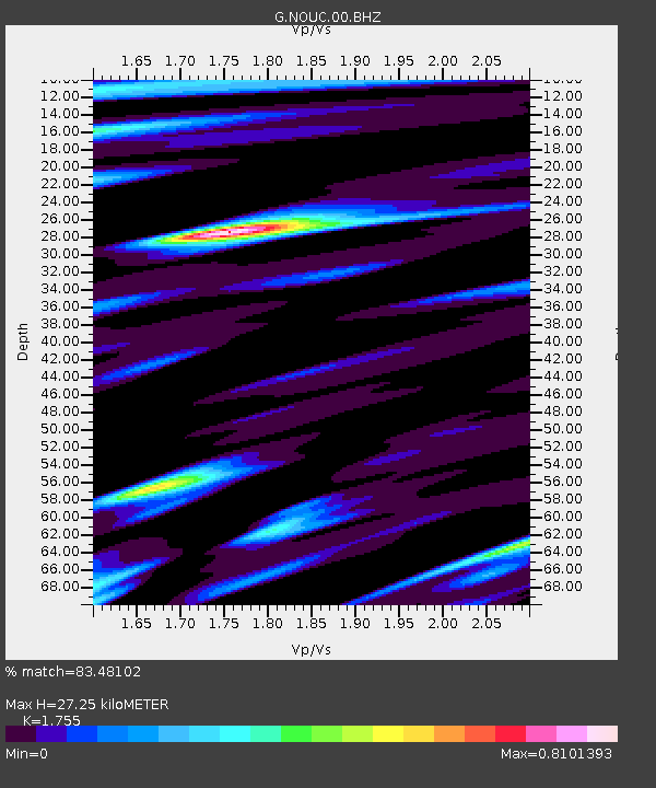
| Estimated Moho Depth: |
27.25 km |
| Estimated Crust Vp/Vs: |
1.75 |
| Assumed Crust Vp: |
5.14 km/s |
| Estimated Crust Vs: |
2.929 km/s |
| Estimated Crust Poisson's Ratio: |
0.26 |
|
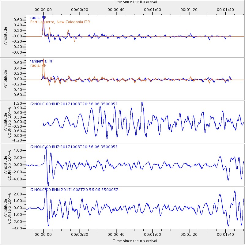
| Radial Match: |
83.48102 % |
| Radial Bump: |
285 |
| Transverse Match: |
56.402092 % |
| Transverse Bump: |
337 |
| SOD ConfigId: |
2364251 |
| Insert Time: |
2017-10-22 20:50:08.077 +0000 |
| GWidth: |
2.5 |
| Max Bumps: |
400 |
| Tol: |
0.001 |
|
Signal To Noise
| Channel | StoN | STA | LTA |
| G:NOUC:00:BHZ:20171008T20:56:06.350005Z | 20.64068 | 3.0438862E-6 | 1.4747025E-7 |
| G:NOUC:00:BHN:20171008T20:56:06.350005Z | 8.292986 | 1.5671728E-6 | 1.889757E-7 |
| G:NOUC:00:BHE:20171008T20:56:06.350005Z | 2.1875365 | 6.0952027E-7 | 2.786332E-7 |
| Arrivals |
| Ps | 4.2 SECOND |
| PpPs | 14 SECOND |
| PsPs/PpSs | 18 SECOND |


