You are here: Home > Network List > IU - Global Seismograph Network (GSN - IRIS/USGS) Stations List
> Station CTAO Charters Towers, Australia > Earthquake Result Viewer
CTAO Charters Towers, Australia - Earthquake Result Viewer

| Earthquake location: |
Balleny Islands Region |
| Earthquake latitude/longitude: |
-61.7/154.6 |
| Earthquake time(UTC): |
2017/10/08 (281) 20:48:58 GMT |
| Earthquake Depth: |
10 km |
| Earthquake Magnitude: |
6.3 Mww |
| Earthquake Catalog/Contributor: |
NEIC PDE/us |
|
| Network: |
IU Global Seismograph Network (GSN - IRIS/USGS) |
| Station: |
CTAO Charters Towers, Australia |
| Lat/Lon: |
20.09 S/146.25 E |
| Elevation: |
357 m |
|
| Distance: |
42.0 deg |
| Az: |
348.308 deg |
| Baz: |
174.111 deg |
| Ray Param: |
0.07342134 |
| Estimated Moho Depth: |
26.75 km |
| Estimated Crust Vp/Vs: |
1.71 |
| Assumed Crust Vp: |
6.522 km/s |
| Estimated Crust Vs: |
3.814 km/s |
| Estimated Crust Poisson's Ratio: |
0.24 |
|
| Radial Match: |
96.170334 % |
| Radial Bump: |
253 |
| Transverse Match: |
81.58982 % |
| Transverse Bump: |
400 |
| SOD ConfigId: |
2364251 |
| Insert Time: |
2017-10-22 20:51:18.425 +0000 |
| GWidth: |
2.5 |
| Max Bumps: |
400 |
| Tol: |
0.001 |
|
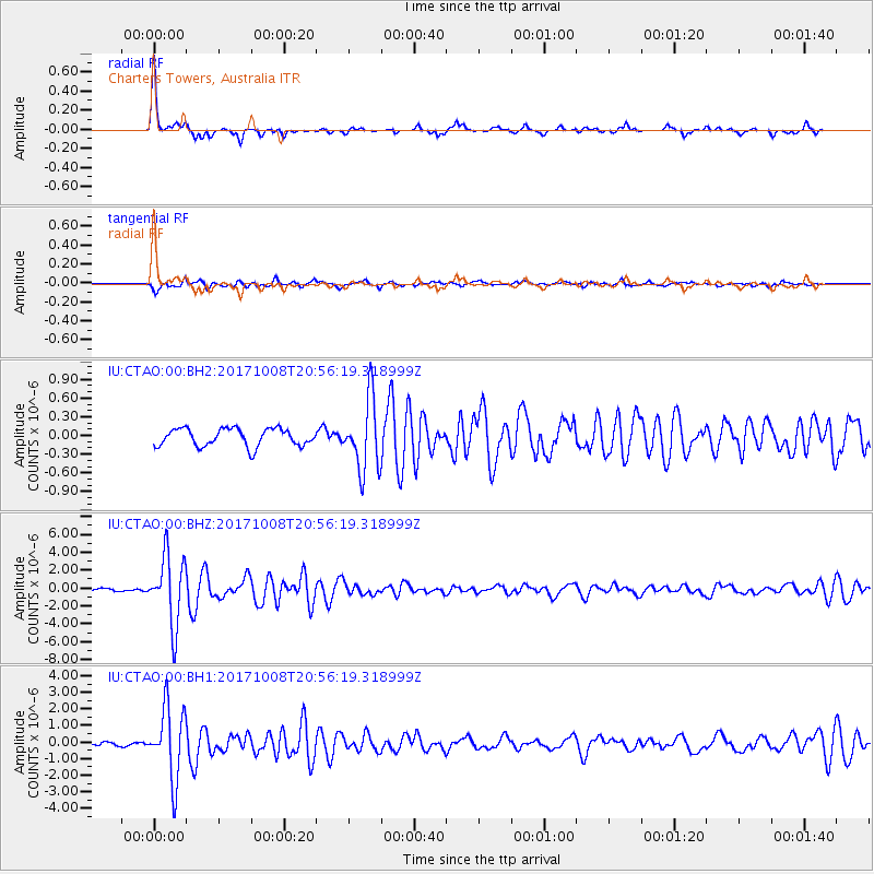
Signal To Noise
| Channel | StoN | STA | LTA |
| IU:CTAO:00:BHZ:20171008T20:56:19.318999Z | 27.19241 | 3.8261333E-6 | 1.4070592E-7 |
| IU:CTAO:00:BH1:20171008T20:56:19.318999Z | 18.638561 | 2.1577066E-6 | 1.1576573E-7 |
| IU:CTAO:00:BH2:20171008T20:56:19.318999Z | 3.9971786 | 5.608322E-7 | 1.4030701E-7 |
| Arrivals |
| Ps | 3.1 SECOND |
| PpPs | 10 SECOND |
| PsPs/PpSs | 13 SECOND |


