You are here: Home > Network List > CI - Caltech Regional Seismic Network Stations List
> Station SWS Sam W. Stewart, Westmorland, CA, USA > Earthquake Result Viewer
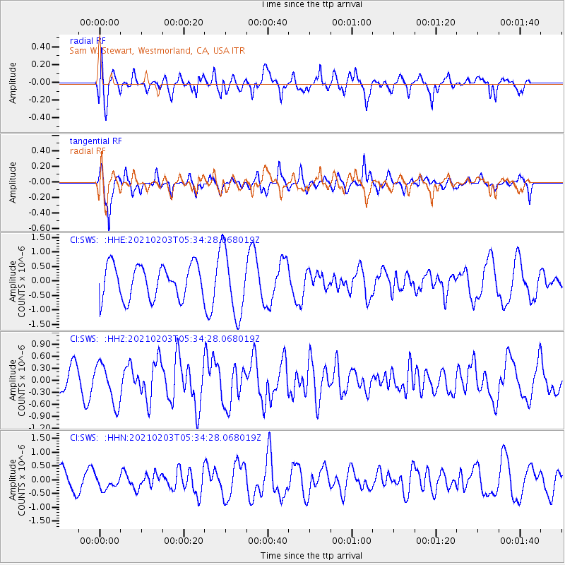
SWS Sam W. Stewart, Westmorland, CA, USA - Earthquake Result Viewer
*The percent match for this event was below the threshold and hence no stack was calculated.
| Earthquake location: |
Southeast Of Easter Island |
| Earthquake latitude/longitude: |
-36.4/-98.2 |
| Earthquake time(UTC): |
2021/02/03 (034) 05:23:41 GMT |
| Earthquake Depth: |
10 km |
| Earthquake Magnitude: |
6.9 mww |
| Earthquake Catalog/Contributor: |
NEIC PDE/us |
|
| Network: |
CI Caltech Regional Seismic Network |
| Station: |
SWS Sam W. Stewart, Westmorland, CA, USA |
| Lat/Lon: |
32.94 N/115.80 W |
| Elevation: |
140 m |
|
| Distance: |
71.0 deg |
| Az: |
344.364 deg |
| Baz: |
165.019 deg |
| Ray Param: |
$rayparam |
*The percent match for this event was below the threshold and hence was not used in the summary stack. |
|
| Radial Match: |
70.25197 % |
| Radial Bump: |
400 |
| Transverse Match: |
58.932526 % |
| Transverse Bump: |
290 |
| SOD ConfigId: |
23341671 |
| Insert Time: |
2021-02-17 06:27:46.280 +0000 |
| GWidth: |
2.5 |
| Max Bumps: |
400 |
| Tol: |
0.001 |
|
Signal To Noise
| Channel | StoN | STA | LTA |
| CI:SWS: :HHZ:20210203T05:34:28.068019Z | 2.6445215 | 5.2047096E-7 | 1.9681102E-7 |
| CI:SWS: :HHN:20210203T05:34:28.068019Z | 0.5239059 | 2.269913E-7 | 4.3326733E-7 |
| CI:SWS: :HHE:20210203T05:34:28.068019Z | 1.973573 | 1.1262656E-6 | 5.706734E-7 |
| Arrivals |
| Ps | |
| PpPs | |
| PsPs/PpSs | |


