You are here: Home > Network List > G - GEOSCOPE Stations List
> Station KIP Kipapa, Hawai, U.S.A. (Pacific Ocean) > Earthquake Result Viewer
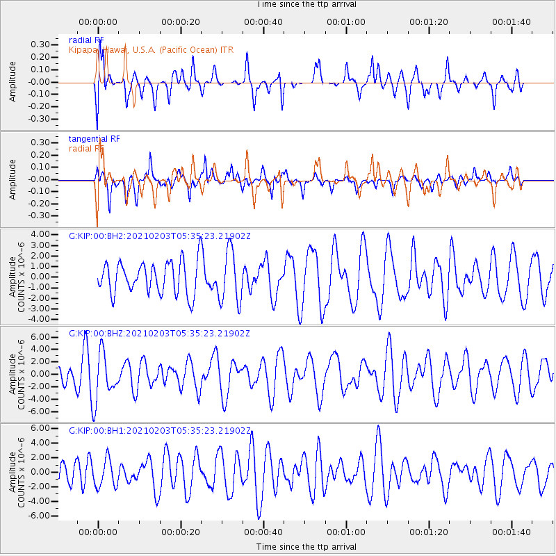
KIP Kipapa, Hawai, U.S.A. (Pacific Ocean) - Earthquake Result Viewer
*The percent match for this event was below the threshold and hence no stack was calculated.
| Earthquake location: |
Southeast Of Easter Island |
| Earthquake latitude/longitude: |
-36.4/-98.2 |
| Earthquake time(UTC): |
2021/02/03 (034) 05:23:41 GMT |
| Earthquake Depth: |
10 km |
| Earthquake Magnitude: |
6.9 mww |
| Earthquake Catalog/Contributor: |
NEIC PDE/us |
|
| Network: |
G GEOSCOPE |
| Station: |
KIP Kipapa, Hawai, U.S.A. (Pacific Ocean) |
| Lat/Lon: |
21.42 N/158.01 W |
| Elevation: |
70 m |
|
| Distance: |
80.6 deg |
| Az: |
305.253 deg |
| Baz: |
135.019 deg |
| Ray Param: |
$rayparam |
*The percent match for this event was below the threshold and hence was not used in the summary stack. |
|
| Radial Match: |
69.89506 % |
| Radial Bump: |
400 |
| Transverse Match: |
51.529045 % |
| Transverse Bump: |
400 |
| SOD ConfigId: |
23341671 |
| Insert Time: |
2021-02-17 06:29:27.789 +0000 |
| GWidth: |
2.5 |
| Max Bumps: |
400 |
| Tol: |
0.001 |
|
Signal To Noise
| Channel | StoN | STA | LTA |
| G:KIP:00:BHZ:20210203T05:35:23.21902Z | 2.0822802 | 3.599574E-6 | 1.7286694E-6 |
| G:KIP:00:BH1:20210203T05:35:23.21902Z | 1.0295235 | 1.9533356E-6 | 1.8973201E-6 |
| G:KIP:00:BH2:20210203T05:35:23.21902Z | 1.6614257 | 2.5181785E-6 | 1.5156731E-6 |
| Arrivals |
| Ps | |
| PpPs | |
| PsPs/PpSs | |


