You are here: Home > Network List > GT - Global Telemetered Seismograph Network (USAF/USGS) Stations List
> Station LPAZ La Paz , Bolivia > Earthquake Result Viewer
LPAZ La Paz , Bolivia - Earthquake Result Viewer
| Earthquake location: |
Southeast Of Easter Island |
| Earthquake latitude/longitude: |
-36.4/-98.2 |
| Earthquake time(UTC): |
2021/02/03 (034) 05:23:41 GMT |
| Earthquake Depth: |
10 km |
| Earthquake Magnitude: |
6.9 mww |
| Earthquake Catalog/Contributor: |
NEIC PDE/us |
|
| Network: |
GT Global Telemetered Seismograph Network (USAF/USGS) |
| Station: |
LPAZ La Paz , Bolivia |
| Lat/Lon: |
16.17 S/68.08 W |
| Elevation: |
4817 m |
|
| Distance: |
33.5 deg |
| Az: |
60.878 deg |
| Baz: |
227.157 deg |
| Ray Param: |
0.078213595 |
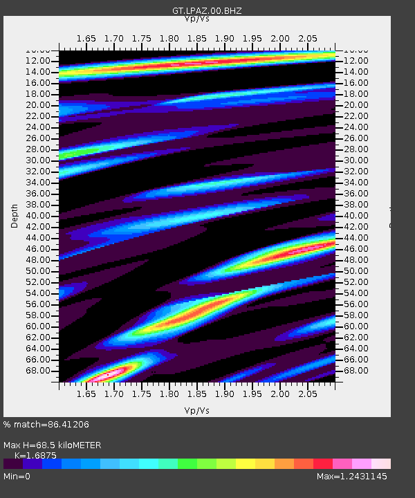
| Estimated Moho Depth: |
68.5 km |
| Estimated Crust Vp/Vs: |
1.69 |
| Assumed Crust Vp: |
6.454 km/s |
| Estimated Crust Vs: |
3.825 km/s |
| Estimated Crust Poisson's Ratio: |
0.23 |
|
| Radial Match: |
86.41206 % |
| Radial Bump: |
400 |
| Transverse Match: |
74.54729 % |
| Transverse Bump: |
400 |
| SOD ConfigId: |
23341671 |
| Insert Time: |
2021-02-17 06:30:01.584 +0000 |
| GWidth: |
2.5 |
| Max Bumps: |
400 |
| Tol: |
0.001 |
|
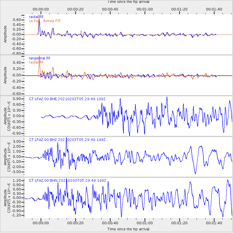
Signal To Noise
| Channel | StoN | STA | LTA |
| GT:LPAZ:00:BHZ:20210203T05:29:49.199Z | 6.6030464 | 6.195124E-7 | 9.38222E-8 |
| GT:LPAZ:00:BHN:20210203T05:29:49.199Z | 4.9796085 | 2.7200878E-7 | 5.462453E-8 |
| GT:LPAZ:00:BHE:20210203T05:29:49.199Z | 4.9063597 | 2.2155774E-7 | 4.5157257E-8 |
| Arrivals |
| Ps | 7.9 SECOND |
| PpPs | 26 SECOND |
| PsPs/PpSs | 34 SECOND |


