You are here: Home > Network List > CI - Caltech Regional Seismic Network Stations List
> Station MPM Manuel Prospect Mine, California, USA > Earthquake Result Viewer
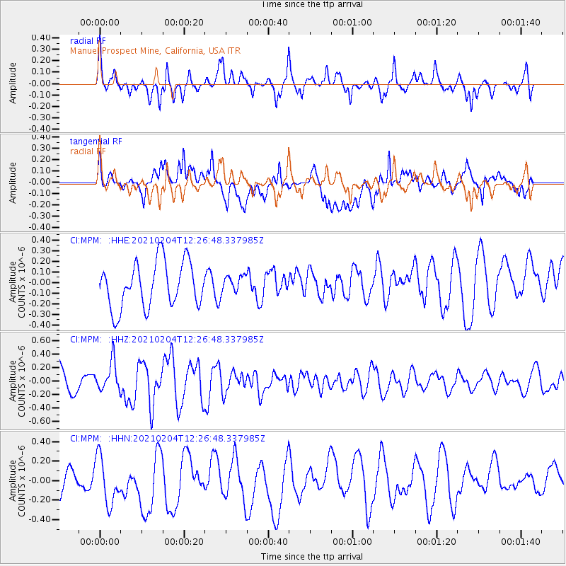
MPM Manuel Prospect Mine, California, USA - Earthquake Result Viewer
*The percent match for this event was below the threshold and hence no stack was calculated.
| Earthquake location: |
Southeast Of Loyalty Islands |
| Earthquake latitude/longitude: |
-22.6/171.9 |
| Earthquake time(UTC): |
2021/02/04 (035) 12:14:26 GMT |
| Earthquake Depth: |
10 km |
| Earthquake Magnitude: |
5.7 mww |
| Earthquake Catalog/Contributor: |
NEIC PDE/us |
|
| Network: |
CI Caltech Regional Seismic Network |
| Station: |
MPM Manuel Prospect Mine, California, USA |
| Lat/Lon: |
36.06 N/117.49 W |
| Elevation: |
185 m |
|
| Distance: |
88.6 deg |
| Az: |
49.852 deg |
| Baz: |
240.648 deg |
| Ray Param: |
$rayparam |
*The percent match for this event was below the threshold and hence was not used in the summary stack. |
|
| Radial Match: |
54.952965 % |
| Radial Bump: |
400 |
| Transverse Match: |
61.493572 % |
| Transverse Bump: |
400 |
| SOD ConfigId: |
23341671 |
| Insert Time: |
2021-02-18 13:21:02.598 +0000 |
| GWidth: |
2.5 |
| Max Bumps: |
400 |
| Tol: |
0.001 |
|
Signal To Noise
| Channel | StoN | STA | LTA |
| CI:MPM: :HHZ:20210204T12:26:48.337985Z | 1.0580673 | 2.2610621E-7 | 2.1369738E-7 |
| CI:MPM: :HHN:20210204T12:26:48.337985Z | 1.2244391 | 2.8370107E-7 | 2.3169879E-7 |
| CI:MPM: :HHE:20210204T12:26:48.337985Z | 0.34894824 | 7.4775684E-8 | 2.1428875E-7 |
| Arrivals |
| Ps | |
| PpPs | |
| PsPs/PpSs | |


