You are here: Home > Network List > TA - USArray Transportable Network (new EarthScope stations) Stations List
> Station F26K Sheenjek River, AK, USA > Earthquake Result Viewer
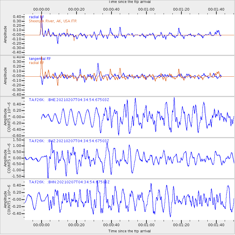
F26K Sheenjek River, AK, USA - Earthquake Result Viewer
*The percent match for this event was below the threshold and hence no stack was calculated.
| Earthquake location: |
Mindanao, Philippines |
| Earthquake latitude/longitude: |
6.8/125.2 |
| Earthquake time(UTC): |
2021/02/07 (038) 04:22:56 GMT |
| Earthquake Depth: |
16 km |
| Earthquake Magnitude: |
6.0 Mww |
| Earthquake Catalog/Contributor: |
NEIC PDE/us |
|
| Network: |
TA USArray Transportable Network (new EarthScope stations) |
| Station: |
F26K Sheenjek River, AK, USA |
| Lat/Lon: |
67.69 N/144.15 W |
| Elevation: |
683 m |
|
| Distance: |
84.0 deg |
| Az: |
22.569 deg |
| Baz: |
273.181 deg |
| Ray Param: |
$rayparam |
*The percent match for this event was below the threshold and hence was not used in the summary stack. |
|
| Radial Match: |
76.88461 % |
| Radial Bump: |
400 |
| Transverse Match: |
69.86829 % |
| Transverse Bump: |
400 |
| SOD ConfigId: |
23341671 |
| Insert Time: |
2021-02-21 05:33:54.984 +0000 |
| GWidth: |
2.5 |
| Max Bumps: |
400 |
| Tol: |
0.001 |
|
Signal To Noise
| Channel | StoN | STA | LTA |
| TA:F26K: :BHZ:20210207T04:34:54.67503Z | 3.387174 | 5.1439713E-7 | 1.5186617E-7 |
| TA:F26K: :BHN:20210207T04:34:54.67503Z | 0.8474343 | 1.0962788E-7 | 1.2936445E-7 |
| TA:F26K: :BHE:20210207T04:34:54.67503Z | 1.8245898 | 2.574401E-7 | 1.4109477E-7 |
| Arrivals |
| Ps | |
| PpPs | |
| PsPs/PpSs | |


