You are here: Home > Network List > GE - GEOFON Stations List
> Station CART UCM/ROA/GEOFON Station Cartagena, Spain, > Earthquake Result Viewer
CART UCM/ROA/GEOFON Station Cartagena, Spain, - Earthquake Result Viewer
| Earthquake location: |
Washington |
| Earthquake latitude/longitude: |
47.1/-122.7 |
| Earthquake time(UTC): |
2001/02/28 (059) 18:54:32 GMT |
| Earthquake Depth: |
52 km |
| Earthquake Magnitude: |
6.5 MB, 6.6 MS, 6.8 MW, 6.7 ME |
| Earthquake Catalog/Contributor: |
WHDF/NEIC |
|
| Network: |
GE GEOFON |
| Station: |
CART UCM/ROA/GEOFON Station Cartagena, Spain, |
| Lat/Lon: |
37.59 N/1.00 W |
| Elevation: |
65 m |
|
| Distance: |
80.9 deg |
| Az: |
43.187 deg |
| Baz: |
323.984 deg |
| Ray Param: |
0.047895033 |
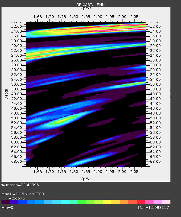
| Estimated Moho Depth: |
12.5 km |
| Estimated Crust Vp/Vs: |
2.10 |
| Assumed Crust Vp: |
5.782 km/s |
| Estimated Crust Vs: |
2.757 km/s |
| Estimated Crust Poisson's Ratio: |
0.35 |
|
| Radial Match: |
83.43395 % |
| Radial Bump: |
400 |
| Transverse Match: |
77.65345 % |
| Transverse Bump: |
400 |
| SOD ConfigId: |
3744 |
| Insert Time: |
2010-03-09 05:13:07.876 +0000 |
| GWidth: |
2.5 |
| Max Bumps: |
400 |
| Tol: |
0.001 |
|

Signal To Noise
| Channel | StoN | STA | LTA |
| GE:CART: :BHN:20010228T19:06:10.220015Z | 2.6042705 | 1.0391218E-6 | 3.9900686E-7 |
| GE:CART: :BHE:20010228T19:06:10.220015Z | 1.9045335 | 8.721406E-7 | 4.5792873E-7 |
| GE:CART: :BHZ:20010228T19:06:10.220015Z | 5.2838907 | 2.821949E-6 | 5.340665E-7 |
| Arrivals |
| Ps | 2.4 SECOND |
| PpPs | 6.6 SECOND |
| PsPs/PpSs | 9.0 SECOND |


