You are here: Home > Network List > TA - USArray Transportable Network (new EarthScope stations) Stations List
> Station I17K Unalakleet, AK, USA > Earthquake Result Viewer
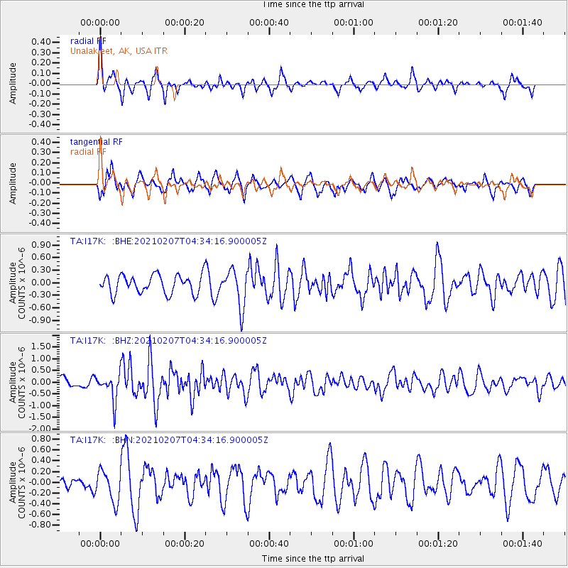
I17K Unalakleet, AK, USA - Earthquake Result Viewer
*The percent match for this event was below the threshold and hence no stack was calculated.
| Earthquake location: |
Mindanao, Philippines |
| Earthquake latitude/longitude: |
6.8/125.2 |
| Earthquake time(UTC): |
2021/02/07 (038) 04:22:56 GMT |
| Earthquake Depth: |
16 km |
| Earthquake Magnitude: |
6.0 Mww |
| Earthquake Catalog/Contributor: |
NEIC PDE/us |
|
| Network: |
TA USArray Transportable Network (new EarthScope stations) |
| Station: |
I17K Unalakleet, AK, USA |
| Lat/Lon: |
63.89 N/160.70 W |
| Elevation: |
105 m |
|
| Distance: |
77.0 deg |
| Az: |
25.904 deg |
| Baz: |
258.63 deg |
| Ray Param: |
$rayparam |
*The percent match for this event was below the threshold and hence was not used in the summary stack. |
|
| Radial Match: |
57.968166 % |
| Radial Bump: |
327 |
| Transverse Match: |
63.65835 % |
| Transverse Bump: |
400 |
| SOD ConfigId: |
23341671 |
| Insert Time: |
2021-02-21 05:34:13.727 +0000 |
| GWidth: |
2.5 |
| Max Bumps: |
400 |
| Tol: |
0.001 |
|
Signal To Noise
| Channel | StoN | STA | LTA |
| TA:I17K: :BHZ:20210207T04:34:16.900005Z | 2.9644246 | 5.7742E-7 | 1.9478317E-7 |
| TA:I17K: :BHN:20210207T04:34:16.900005Z | 1.9486002 | 2.954819E-7 | 1.5163803E-7 |
| TA:I17K: :BHE:20210207T04:34:16.900005Z | 2.097375 | 4.6235115E-7 | 2.2044279E-7 |
| Arrivals |
| Ps | |
| PpPs | |
| PsPs/PpSs | |


