You are here: Home > Network List > TA - USArray Transportable Network (new EarthScope stations) Stations List
> Station L15K Ungalak Mountain, AK, USA > Earthquake Result Viewer
L15K Ungalak Mountain, AK, USA - Earthquake Result Viewer
*The percent match for this event was below the threshold and hence no stack was calculated.
| Earthquake location: |
Mindanao, Philippines |
| Earthquake latitude/longitude: |
6.8/125.2 |
| Earthquake time(UTC): |
2021/02/07 (038) 04:22:56 GMT |
| Earthquake Depth: |
16 km |
| Earthquake Magnitude: |
6.0 Mww |
| Earthquake Catalog/Contributor: |
NEIC PDE/us |
|
| Network: |
TA USArray Transportable Network (new EarthScope stations) |
| Station: |
L15K Ungalak Mountain, AK, USA |
| Lat/Lon: |
61.68 N/161.49 W |
| Elevation: |
219 m |
|
| Distance: |
76.2 deg |
| Az: |
28.064 deg |
| Baz: |
258.429 deg |
| Ray Param: |
$rayparam |
*The percent match for this event was below the threshold and hence was not used in the summary stack. |
|
| Radial Match: |
52.533714 % |
| Radial Bump: |
333 |
| Transverse Match: |
62.61228 % |
| Transverse Bump: |
327 |
| SOD ConfigId: |
23341671 |
| Insert Time: |
2021-02-21 05:34:25.185 +0000 |
| GWidth: |
2.5 |
| Max Bumps: |
400 |
| Tol: |
0.001 |
|
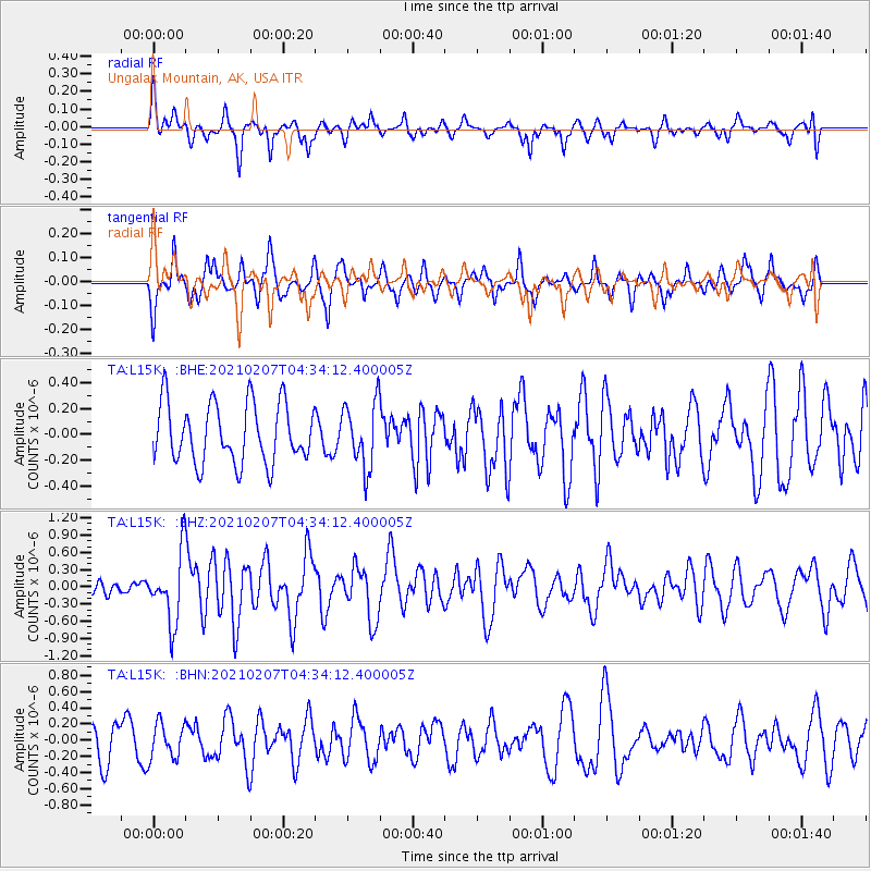
Signal To Noise
| Channel | StoN | STA | LTA |
| TA:L15K: :BHZ:20210207T04:34:12.400005Z | 2.4458778 | 5.983175E-7 | 2.4462284E-7 |
| TA:L15K: :BHN:20210207T04:34:12.400005Z | 0.8559902 | 2.1819555E-7 | 2.5490428E-7 |
| TA:L15K: :BHE:20210207T04:34:12.400005Z | 1.103586 | 2.5446764E-7 | 2.3058251E-7 |
| Arrivals |
| Ps | |
| PpPs | |
| PsPs/PpSs | |


