You are here: Home > Network List > PS - Pacific21 Stations List
> Station PSI Parapat, Indonesia > Earthquake Result Viewer
PSI Parapat, Indonesia - Earthquake Result Viewer
| Earthquake location: |
Bismarck Sea |
| Earthquake latitude/longitude: |
-3.3/146.1 |
| Earthquake time(UTC): |
2021/02/07 (038) 05:45:52 GMT |
| Earthquake Depth: |
10 km |
| Earthquake Magnitude: |
6.3 Mww |
| Earthquake Catalog/Contributor: |
NEIC PDE/us |
|
| Network: |
PS Pacific21 |
| Station: |
PSI Parapat, Indonesia |
| Lat/Lon: |
2.69 N/98.92 E |
| Elevation: |
987 m |
|
| Distance: |
47.5 deg |
| Az: |
276.651 deg |
| Baz: |
96.911 deg |
| Ray Param: |
0.069958135 |
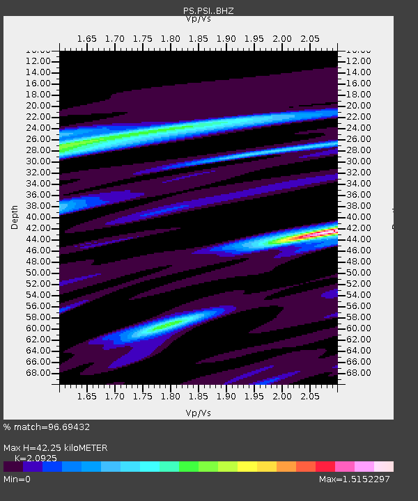
| Estimated Moho Depth: |
42.25 km |
| Estimated Crust Vp/Vs: |
2.09 |
| Assumed Crust Vp: |
6.468 km/s |
| Estimated Crust Vs: |
3.091 km/s |
| Estimated Crust Poisson's Ratio: |
0.35 |
|
| Radial Match: |
96.69432 % |
| Radial Bump: |
318 |
| Transverse Match: |
86.69523 % |
| Transverse Bump: |
400 |
| SOD ConfigId: |
23341671 |
| Insert Time: |
2021-02-21 06:54:18.118 +0000 |
| GWidth: |
2.5 |
| Max Bumps: |
400 |
| Tol: |
0.001 |
|
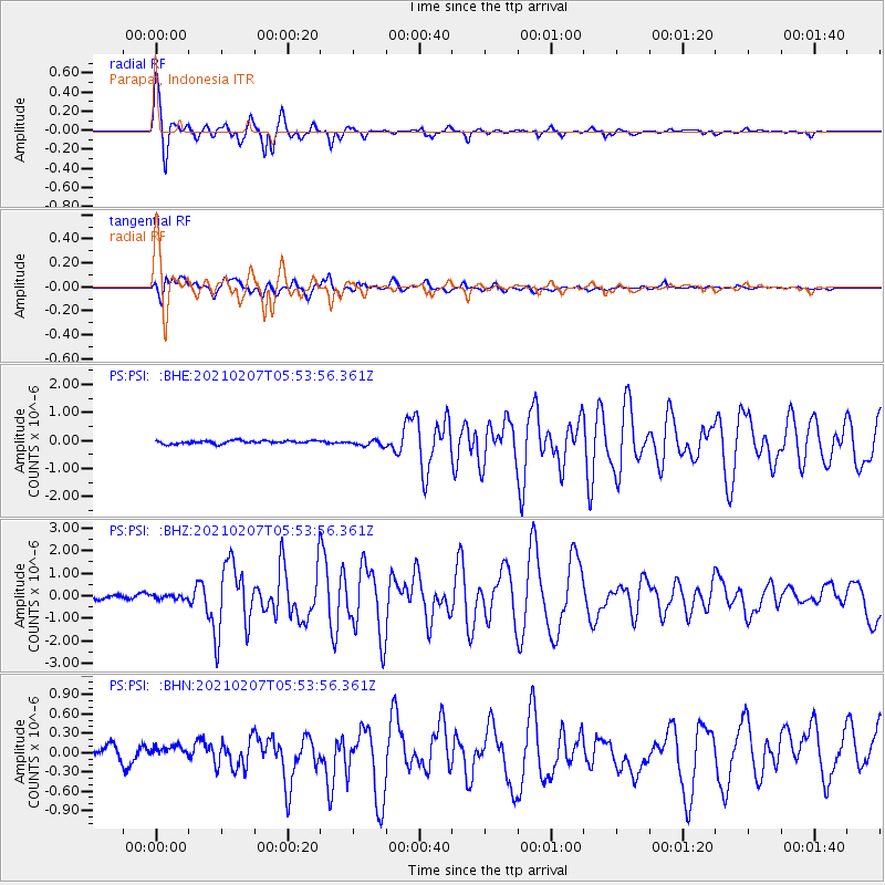
Signal To Noise
| Channel | StoN | STA | LTA |
| PS:PSI: :BHZ:20210207T05:53:56.361Z | 1.0375335 | 8.6047365E-8 | 8.293454E-8 |
| PS:PSI: :BHN:20210207T05:53:56.361Z | 0.8122888 | 8.0660335E-8 | 9.930007E-8 |
| PS:PSI: :BHE:20210207T05:53:56.361Z | 1.8991643 | 1.0627685E-7 | 5.59598E-8 |
| Arrivals |
| Ps | 7.5 SECOND |
| PpPs | 19 SECOND |
| PsPs/PpSs | 27 SECOND |


