You are here: Home > Network List > TA - USArray Transportable Network (new EarthScope stations) Stations List
> Station R33M Jennings River, BC, CAN > Earthquake Result Viewer
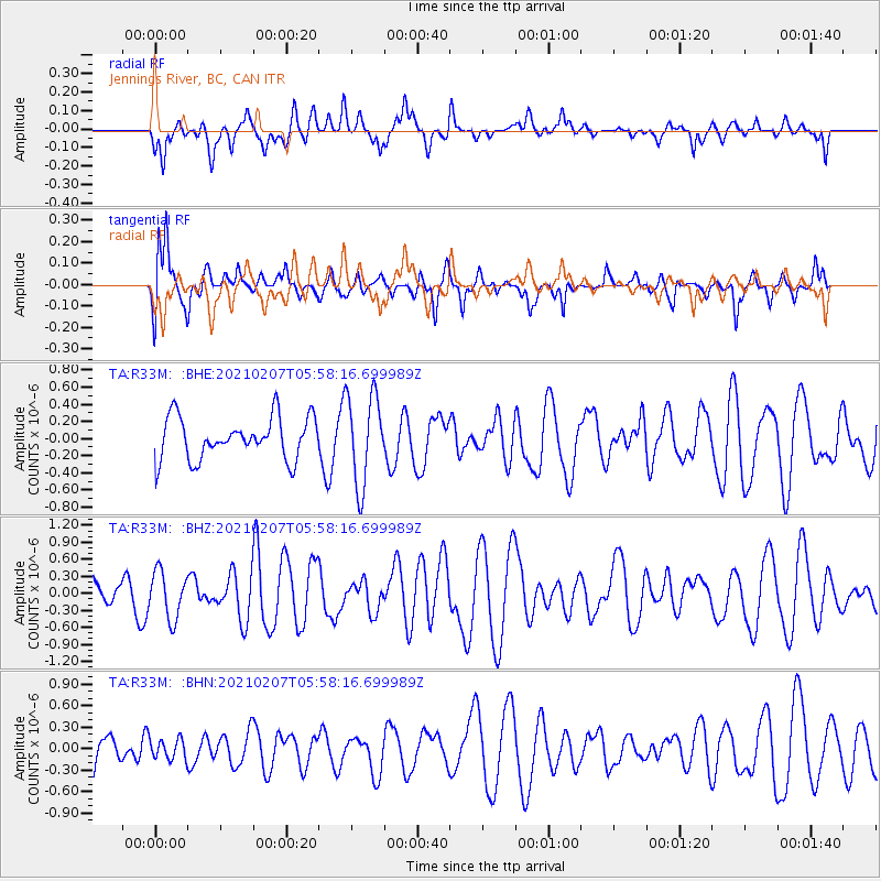
R33M Jennings River, BC, CAN - Earthquake Result Viewer
*The percent match for this event was below the threshold and hence no stack was calculated.
| Earthquake location: |
Bismarck Sea |
| Earthquake latitude/longitude: |
-3.3/146.1 |
| Earthquake time(UTC): |
2021/02/07 (038) 05:45:52 GMT |
| Earthquake Depth: |
10 km |
| Earthquake Magnitude: |
6.3 Mww |
| Earthquake Catalog/Contributor: |
NEIC PDE/us |
|
| Network: |
TA USArray Transportable Network (new EarthScope stations) |
| Station: |
R33M Jennings River, BC, CAN |
| Lat/Lon: |
59.39 N/130.97 W |
| Elevation: |
1437 m |
|
| Distance: |
89.2 deg |
| Az: |
30.521 deg |
| Baz: |
262.291 deg |
| Ray Param: |
$rayparam |
*The percent match for this event was below the threshold and hence was not used in the summary stack. |
|
| Radial Match: |
44.74816 % |
| Radial Bump: |
400 |
| Transverse Match: |
74.08261 % |
| Transverse Bump: |
400 |
| SOD ConfigId: |
23341671 |
| Insert Time: |
2021-02-21 06:55:30.994 +0000 |
| GWidth: |
2.5 |
| Max Bumps: |
400 |
| Tol: |
0.001 |
|
Signal To Noise
| Channel | StoN | STA | LTA |
| TA:R33M: :BHZ:20210207T05:58:16.699989Z | 1.3271563 | 4.116503E-7 | 3.101747E-7 |
| TA:R33M: :BHN:20210207T05:58:16.699989Z | 0.4369576 | 1.384585E-7 | 3.1686943E-7 |
| TA:R33M: :BHE:20210207T05:58:16.699989Z | 2.1636977 | 5.2474377E-7 | 2.4252176E-7 |
| Arrivals |
| Ps | |
| PpPs | |
| PsPs/PpSs | |


