You are here: Home > Network List > G - GEOSCOPE Stations List
> Station NOUC Port Laguerre, New Caledonia > Earthquake Result Viewer
NOUC Port Laguerre, New Caledonia - Earthquake Result Viewer

| Earthquake location: |
Rat Islands, Aleutian Islands |
| Earthquake latitude/longitude: |
52.4/176.8 |
| Earthquake time(UTC): |
2017/10/08 (281) 22:34:33 GMT |
| Earthquake Depth: |
112 km |
| Earthquake Magnitude: |
6.6 mww |
| Earthquake Catalog/Contributor: |
NEIC PDE/us |
|
| Network: |
G GEOSCOPE |
| Station: |
NOUC Port Laguerre, New Caledonia |
| Lat/Lon: |
22.10 S/166.30 E |
| Elevation: |
112 m |
|
| Distance: |
74.8 deg |
| Az: |
190.091 deg |
| Baz: |
6.64 deg |
| Ray Param: |
0.051828474 |
| Estimated Moho Depth: |
21.75 km |
| Estimated Crust Vp/Vs: |
2.02 |
| Assumed Crust Vp: |
5.14 km/s |
| Estimated Crust Vs: |
2.551 km/s |
| Estimated Crust Poisson's Ratio: |
0.34 |
|
| Radial Match: |
88.576996 % |
| Radial Bump: |
400 |
| Transverse Match: |
70.16309 % |
| Transverse Bump: |
400 |
| SOD ConfigId: |
2364251 |
| Insert Time: |
2017-10-22 22:40:21.469 +0000 |
| GWidth: |
2.5 |
| Max Bumps: |
400 |
| Tol: |
0.001 |
|
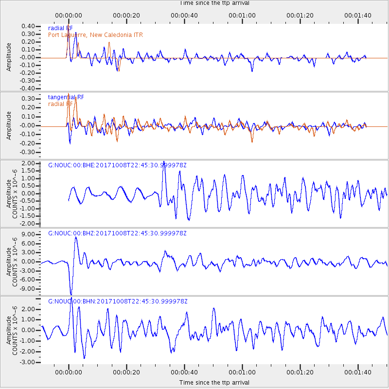
Signal To Noise
| Channel | StoN | STA | LTA |
| G:NOUC:00:BHZ:20171008T22:45:30.999978Z | 24.25533 | 5.352935E-6 | 2.206911E-7 |
| G:NOUC:00:BHN:20171008T22:45:30.999978Z | 5.128999 | 1.5989194E-6 | 3.11741E-7 |
| G:NOUC:00:BHE:20171008T22:45:30.999978Z | 2.8680584 | 8.6831676E-7 | 3.0275422E-7 |
| Arrivals |
| Ps | 4.4 SECOND |
| PpPs | 13 SECOND |
| PsPs/PpSs | 17 SECOND |


