You are here: Home > Network List > GE - GEOFON Stations List
> Station CART UCM/ROA/GEOFON Station Cartagena, Spain, > Earthquake Result Viewer
CART UCM/ROA/GEOFON Station Cartagena, Spain, - Earthquake Result Viewer
| Earthquake location: |
Near Coast Of Jalisco, Mexico |
| Earthquake latitude/longitude: |
18.8/-104.1 |
| Earthquake time(UTC): |
2003/01/22 (022) 02:06:34 GMT |
| Earthquake Depth: |
24 km |
| Earthquake Magnitude: |
6.5 MB, 7.6 MS, 7.6 MW, 7.4 MW |
| Earthquake Catalog/Contributor: |
WHDF/NEIC |
|
| Network: |
GE GEOFON |
| Station: |
CART UCM/ROA/GEOFON Station Cartagena, Spain, |
| Lat/Lon: |
37.59 N/1.00 W |
| Elevation: |
65 m |
|
| Distance: |
88.6 deg |
| Az: |
50.709 deg |
| Baz: |
292.622 deg |
| Ray Param: |
0.042406943 |
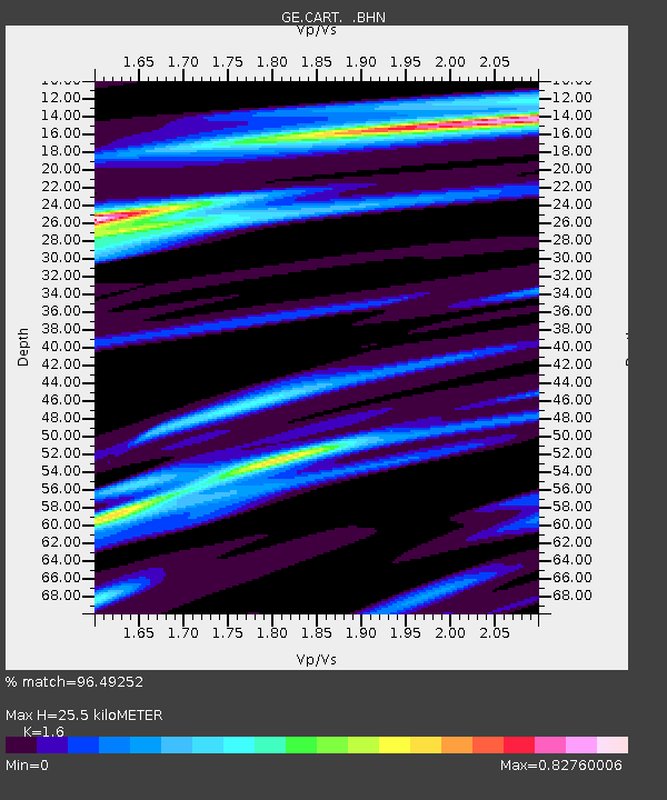
| Estimated Moho Depth: |
25.5 km |
| Estimated Crust Vp/Vs: |
1.60 |
| Assumed Crust Vp: |
5.782 km/s |
| Estimated Crust Vs: |
3.614 km/s |
| Estimated Crust Poisson's Ratio: |
0.18 |
|
| Radial Match: |
96.49252 % |
| Radial Bump: |
400 |
| Transverse Match: |
85.52962 % |
| Transverse Bump: |
400 |
| SOD ConfigId: |
4714 |
| Insert Time: |
2010-03-09 05:13:41.398 +0000 |
| GWidth: |
2.5 |
| Max Bumps: |
400 |
| Tol: |
0.001 |
|

Signal To Noise
| Channel | StoN | STA | LTA |
| GE:CART: :BHN:20030122T02:18:54.214004Z | 0.54651356 | 3.113029E-7 | 5.696161E-7 |
| GE:CART: :BHE:20030122T02:18:54.214004Z | 2.7175162 | 9.811893E-7 | 3.6106104E-7 |
| GE:CART: :BHZ:20030122T02:18:54.214004Z | 4.792689 | 2.7695517E-6 | 5.778701E-7 |
| Arrivals |
| Ps | 2.7 SECOND |
| PpPs | 11 SECOND |
| PsPs/PpSs | 14 SECOND |


