You are here: Home > Network List > TA - USArray Transportable Network (new EarthScope stations) Stations List
> Station G16K Koyuk River, AK, USA > Earthquake Result Viewer
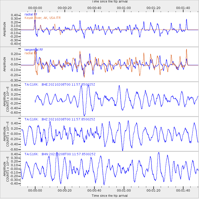
G16K Koyuk River, AK, USA - Earthquake Result Viewer
*The percent match for this event was below the threshold and hence no stack was calculated.
| Earthquake location: |
Philippine Islands Region |
| Earthquake latitude/longitude: |
5.7/127.1 |
| Earthquake time(UTC): |
2021/02/08 (039) 00:00:42 GMT |
| Earthquake Depth: |
51 km |
| Earthquake Magnitude: |
5.6 Mww |
| Earthquake Catalog/Contributor: |
NEIC PDE/us |
|
| Network: |
TA USArray Transportable Network (new EarthScope stations) |
| Station: |
G16K Koyuk River, AK, USA |
| Lat/Lon: |
65.39 N/162.35 W |
| Elevation: |
169 m |
|
| Distance: |
76.8 deg |
| Az: |
23.93 deg |
| Baz: |
254.583 deg |
| Ray Param: |
$rayparam |
*The percent match for this event was below the threshold and hence was not used in the summary stack. |
|
| Radial Match: |
52.941345 % |
| Radial Bump: |
340 |
| Transverse Match: |
54.668938 % |
| Transverse Bump: |
400 |
| SOD ConfigId: |
23341671 |
| Insert Time: |
2021-02-22 01:08:05.594 +0000 |
| GWidth: |
2.5 |
| Max Bumps: |
400 |
| Tol: |
0.001 |
|
Signal To Noise
| Channel | StoN | STA | LTA |
| TA:G16K: :BHZ:20210208T00:11:57.850025Z | 1.0997465 | 2.6031142E-7 | 2.3670131E-7 |
| TA:G16K: :BHN:20210208T00:11:57.850025Z | 0.7284229 | 9.850602E-8 | 1.3523191E-7 |
| TA:G16K: :BHE:20210208T00:11:57.850025Z | 3.3066092 | 4.4651998E-7 | 1.3503863E-7 |
| Arrivals |
| Ps | |
| PpPs | |
| PsPs/PpSs | |


