You are here: Home > Network List > GS - US Geological Survey Networks Stations List
> Station DEC05 Apollo Drive Surface Site > Earthquake Result Viewer
DEC05 Apollo Drive Surface Site - Earthquake Result Viewer

| Earthquake location: |
Rat Islands, Aleutian Islands |
| Earthquake latitude/longitude: |
52.4/176.8 |
| Earthquake time(UTC): |
2017/10/08 (281) 22:34:33 GMT |
| Earthquake Depth: |
112 km |
| Earthquake Magnitude: |
6.6 mww |
| Earthquake Catalog/Contributor: |
NEIC PDE/us |
|
| Network: |
GS US Geological Survey Networks |
| Station: |
DEC05 Apollo Drive Surface Site |
| Lat/Lon: |
39.87 N/88.87 W |
| Elevation: |
216 m |
|
| Distance: |
62.0 deg |
| Az: |
60.358 deg |
| Baz: |
316.277 deg |
| Ray Param: |
0.060193475 |
| Estimated Moho Depth: |
25.0 km |
| Estimated Crust Vp/Vs: |
1.96 |
| Assumed Crust Vp: |
6.444 km/s |
| Estimated Crust Vs: |
3.296 km/s |
| Estimated Crust Poisson's Ratio: |
0.32 |
|
| Radial Match: |
85.39822 % |
| Radial Bump: |
400 |
| Transverse Match: |
71.76735 % |
| Transverse Bump: |
400 |
| SOD ConfigId: |
2364251 |
| Insert Time: |
2017-10-22 22:41:36.176 +0000 |
| GWidth: |
2.5 |
| Max Bumps: |
400 |
| Tol: |
0.001 |
|
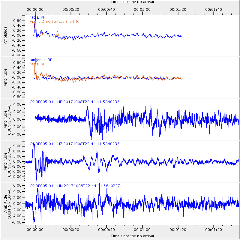
Signal To Noise
| Channel | StoN | STA | LTA |
| GS:DEC05:01:HHZ:20171008T22:44:11.584023Z | 17.788704 | 6.1767014E-6 | 3.4722606E-7 |
| GS:DEC05:01:HHN:20171008T22:44:11.584023Z | 3.9823236 | 3.0342699E-6 | 7.6193453E-7 |
| GS:DEC05:01:HHE:20171008T22:44:11.584023Z | 4.5638304 | 2.185742E-6 | 4.7892706E-7 |
| Arrivals |
| Ps | 3.9 SECOND |
| PpPs | 11 SECOND |
| PsPs/PpSs | 15 SECOND |


