You are here: Home > Network List > GS - US Geological Survey Networks Stations List
> Station DEC08 Union Local 159 Surface Site > Earthquake Result Viewer
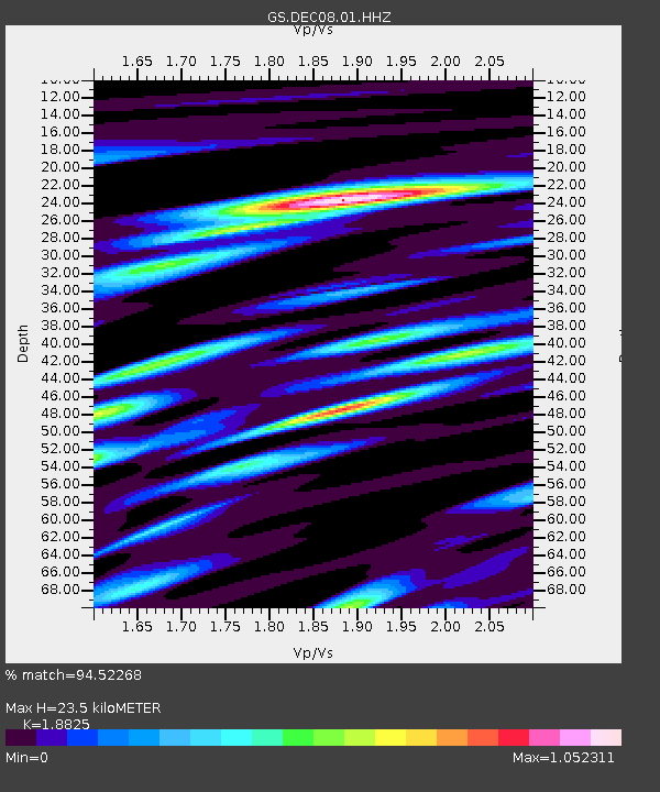
DEC08 Union Local 159 Surface Site - Earthquake Result Viewer
| Earthquake location: |
Rat Islands, Aleutian Islands |
| Earthquake latitude/longitude: |
52.4/176.8 |
| Earthquake time(UTC): |
2017/10/08 (281) 22:34:33 GMT |
| Earthquake Depth: |
112 km |
| Earthquake Magnitude: |
6.6 mww |
| Earthquake Catalog/Contributor: |
NEIC PDE/us |
|
| Network: |
GS US Geological Survey Networks |
| Station: |
DEC08 Union Local 159 Surface Site |
| Lat/Lon: |
39.86 N/88.92 W |
| Elevation: |
210 m |
|
| Distance: |
62.0 deg |
| Az: |
60.402 deg |
| Baz: |
316.26 deg |
| Ray Param: |
0.06020971 |
| Estimated Moho Depth: |
23.5 km |
| Estimated Crust Vp/Vs: |
1.88 |
| Assumed Crust Vp: |
6.444 km/s |
| Estimated Crust Vs: |
3.423 km/s |
| Estimated Crust Poisson's Ratio: |
0.30 |
|
| Radial Match: |
94.52268 % |
| Radial Bump: |
400 |
| Transverse Match: |
79.354355 % |
| Transverse Bump: |
400 |
| SOD ConfigId: |
2364251 |
| Insert Time: |
2017-10-22 22:41:39.435 +0000 |
| GWidth: |
2.5 |
| Max Bumps: |
400 |
| Tol: |
0.001 |
|

Signal To Noise
| Channel | StoN | STA | LTA |
| GS:DEC08:01:HHZ:20171008T22:44:11.418984Z | 8.204728 | 5.9549993E-6 | 7.25801E-7 |
| GS:DEC08:01:HHN:20171008T22:44:11.418984Z | 2.166108 | 2.505326E-6 | 1.1566025E-6 |
| GS:DEC08:01:HHE:20171008T22:44:11.418984Z | 2.3333473 | 2.5774916E-6 | 1.1046326E-6 |
| Arrivals |
| Ps | 3.4 SECOND |
| PpPs | 10 SECOND |
| PsPs/PpSs | 13 SECOND |


