You are here: Home > Network List > GS - US Geological Survey Networks Stations List
> Station MT01 Lincoln Ranger Stn, Helena Natl Forest, Montana, USA > Earthquake Result Viewer
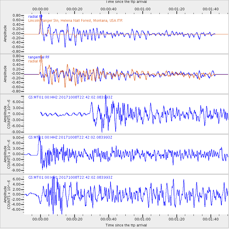
MT01 Lincoln Ranger Stn, Helena Natl Forest, Montana, USA - Earthquake Result Viewer

| Earthquake location: |
Rat Islands, Aleutian Islands |
| Earthquake latitude/longitude: |
52.4/176.8 |
| Earthquake time(UTC): |
2017/10/08 (281) 22:34:33 GMT |
| Earthquake Depth: |
112 km |
| Earthquake Magnitude: |
6.6 mww |
| Earthquake Catalog/Contributor: |
NEIC PDE/us |
|
| Network: |
GS US Geological Survey Networks |
| Station: |
MT01 Lincoln Ranger Stn, Helena Natl Forest, Montana, USA |
| Lat/Lon: |
46.95 N/112.66 W |
| Elevation: |
1318 m |
|
| Distance: |
44.3 deg |
| Az: |
67.666 deg |
| Baz: |
304.269 deg |
| Ray Param: |
0.07163011 |
| Estimated Moho Depth: |
39.25 km |
| Estimated Crust Vp/Vs: |
1.74 |
| Assumed Crust Vp: |
6.353 km/s |
| Estimated Crust Vs: |
3.651 km/s |
| Estimated Crust Poisson's Ratio: |
0.25 |
|
| Radial Match: |
84.90143 % |
| Radial Bump: |
400 |
| Transverse Match: |
75.42574 % |
| Transverse Bump: |
400 |
| SOD ConfigId: |
2364251 |
| Insert Time: |
2017-10-22 22:42:30.744 +0000 |
| GWidth: |
2.5 |
| Max Bumps: |
400 |
| Tol: |
0.001 |
|
Signal To Noise
| Channel | StoN | STA | LTA |
| GS:MT01:00:HHZ:20171008T22:42:02.083993Z | 20.988974 | 5.3601475E-6 | 2.553792E-7 |
| GS:MT01:00:HH1:20171008T22:42:02.083993Z | 4.7074776 | 2.1386375E-6 | 4.5430644E-7 |
| GS:MT01:00:HH2:20171008T22:42:02.083993Z | 7.2622275 | 3.542177E-6 | 4.877535E-7 |
| Arrivals |
| Ps | 4.9 SECOND |
| PpPs | 16 SECOND |
| PsPs/PpSs | 21 SECOND |


