You are here: Home > Network List > US - United States National Seismic Network Stations List
> Station BW06 Boulder Array Site 6 (Pinedale), Wyoming, USA > Earthquake Result Viewer
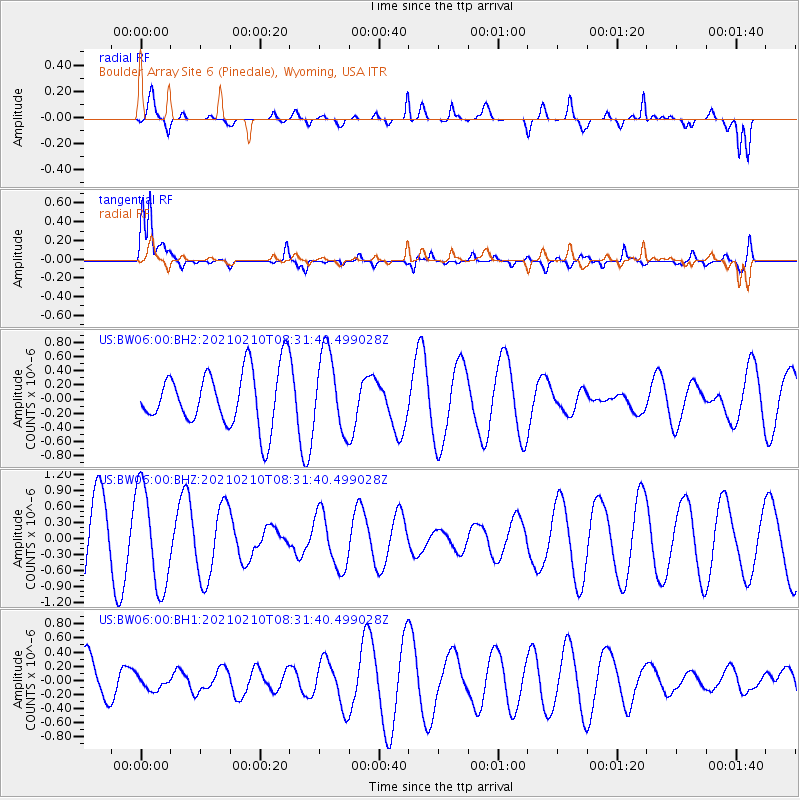
BW06 Boulder Array Site 6 (Pinedale), Wyoming, USA - Earthquake Result Viewer
*The percent match for this event was below the threshold and hence no stack was calculated.
| Earthquake location: |
Central East Pacific Rise |
| Earthquake latitude/longitude: |
-13.6/-111.6 |
| Earthquake time(UTC): |
2021/02/10 (041) 08:22:31 GMT |
| Earthquake Depth: |
10 km |
| Earthquake Magnitude: |
5.6 Mww |
| Earthquake Catalog/Contributor: |
NEIC PDE/us |
|
| Network: |
US United States National Seismic Network |
| Station: |
BW06 Boulder Array Site 6 (Pinedale), Wyoming, USA |
| Lat/Lon: |
42.77 N/109.56 W |
| Elevation: |
2224 m |
|
| Distance: |
56.2 deg |
| Az: |
1.833 deg |
| Baz: |
182.42 deg |
| Ray Param: |
$rayparam |
*The percent match for this event was below the threshold and hence was not used in the summary stack. |
|
| Radial Match: |
61.195553 % |
| Radial Bump: |
400 |
| Transverse Match: |
90.80824 % |
| Transverse Bump: |
400 |
| SOD ConfigId: |
23341671 |
| Insert Time: |
2021-02-24 09:40:33.998 +0000 |
| GWidth: |
2.5 |
| Max Bumps: |
400 |
| Tol: |
0.001 |
|
Signal To Noise
| Channel | StoN | STA | LTA |
| US:BW06:00:BHZ:20210210T08:31:40.499028Z | 1.9516938 | 9.3950507E-7 | 4.8137935E-7 |
| US:BW06:00:BH1:20210210T08:31:40.499028Z | 0.32459342 | 9.420251E-8 | 2.9021695E-7 |
| US:BW06:00:BH2:20210210T08:31:40.499028Z | 1.3834552 | 5.513697E-7 | 3.985454E-7 |
| Arrivals |
| Ps | |
| PpPs | |
| PsPs/PpSs | |


