You are here: Home > Network List > US - United States National Seismic Network Stations List
> Station LRAL Lakeview Retreat, Alabama, USA > Earthquake Result Viewer
LRAL Lakeview Retreat, Alabama, USA - Earthquake Result Viewer
| Earthquake location: |
Central East Pacific Rise |
| Earthquake latitude/longitude: |
-13.6/-111.6 |
| Earthquake time(UTC): |
2021/02/10 (041) 08:22:31 GMT |
| Earthquake Depth: |
10 km |
| Earthquake Magnitude: |
5.6 Mww |
| Earthquake Catalog/Contributor: |
NEIC PDE/us |
|
| Network: |
US United States National Seismic Network |
| Station: |
LRAL Lakeview Retreat, Alabama, USA |
| Lat/Lon: |
33.03 N/87.00 W |
| Elevation: |
130 m |
|
| Distance: |
52.0 deg |
| Az: |
26.359 deg |
| Baz: |
210.919 deg |
| Ray Param: |
0.06701824 |
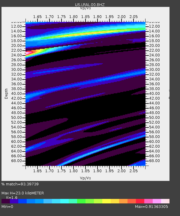
| Estimated Moho Depth: |
23.0 km |
| Estimated Crust Vp/Vs: |
1.60 |
| Assumed Crust Vp: |
6.565 km/s |
| Estimated Crust Vs: |
4.103 km/s |
| Estimated Crust Poisson's Ratio: |
0.18 |
|
| Radial Match: |
93.39739 % |
| Radial Bump: |
400 |
| Transverse Match: |
70.183655 % |
| Transverse Bump: |
400 |
| SOD ConfigId: |
23341671 |
| Insert Time: |
2021-02-24 09:40:46.732 +0000 |
| GWidth: |
2.5 |
| Max Bumps: |
400 |
| Tol: |
0.001 |
|
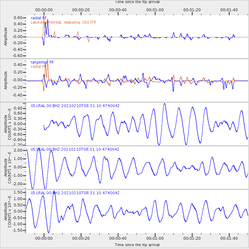
Signal To Noise
| Channel | StoN | STA | LTA |
| US:LRAL:00:BHZ:20210210T08:31:10.474004Z | 1.3694999 | 1.7166127E-6 | 1.2534595E-6 |
| US:LRAL:00:BH1:20210210T08:31:10.474004Z | 1.4281315 | 1.079247E-6 | 7.557056E-7 |
| US:LRAL:00:BH2:20210210T08:31:10.474004Z | 1.3820624 | 4.0245038E-7 | 2.9119553E-7 |
| Arrivals |
| Ps | 2.2 SECOND |
| PpPs | 8.5 SECOND |
| PsPs/PpSs | 11 SECOND |


