You are here: Home > Network List > UU - University of Utah Regional Network Stations List
> Station KNB Kanab, UT, USA > Earthquake Result Viewer
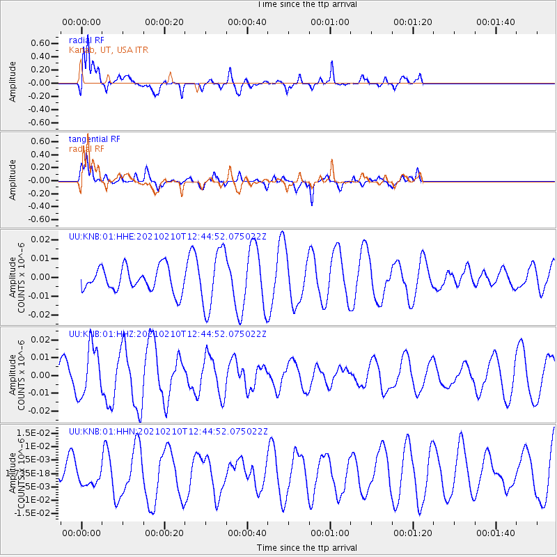
KNB Kanab, UT, USA - Earthquake Result Viewer
*The percent match for this event was below the threshold and hence no stack was calculated.
| Earthquake location: |
Southeast Of Loyalty Islands |
| Earthquake latitude/longitude: |
-22.6/171.5 |
| Earthquake time(UTC): |
2021/02/10 (041) 12:32:11 GMT |
| Earthquake Depth: |
10 km |
| Earthquake Magnitude: |
5.7 mww |
| Earthquake Catalog/Contributor: |
NEIC PDE/us |
|
| Network: |
UU University of Utah Regional Network |
| Station: |
KNB Kanab, UT, USA |
| Lat/Lon: |
37.02 N/112.82 W |
| Elevation: |
1715 m |
|
| Distance: |
92.6 deg |
| Az: |
50.941 deg |
| Baz: |
243.745 deg |
| Ray Param: |
$rayparam |
*The percent match for this event was below the threshold and hence was not used in the summary stack. |
|
| Radial Match: |
69.10931 % |
| Radial Bump: |
400 |
| Transverse Match: |
46.03269 % |
| Transverse Bump: |
368 |
| SOD ConfigId: |
23341671 |
| Insert Time: |
2021-02-24 13:48:07.423 +0000 |
| GWidth: |
2.5 |
| Max Bumps: |
400 |
| Tol: |
0.001 |
|
Signal To Noise
| Channel | StoN | STA | LTA |
| UU:KNB:01:HHZ:20210210T12:44:52.075022Z | 2.1485844 | 1.4265584E-8 | 6.639527E-9 |
| UU:KNB:01:HHN:20210210T12:44:52.075022Z | 0.67970437 | 3.872886E-9 | 5.697898E-9 |
| UU:KNB:01:HHE:20210210T12:44:52.075022Z | 2.5296934 | 1.5984261E-8 | 6.318656E-9 |
| Arrivals |
| Ps | |
| PpPs | |
| PsPs/PpSs | |


