You are here: Home > Network List > G - GEOSCOPE Stations List
> Station TAM Tamanrasset, Algeria > Earthquake Result Viewer
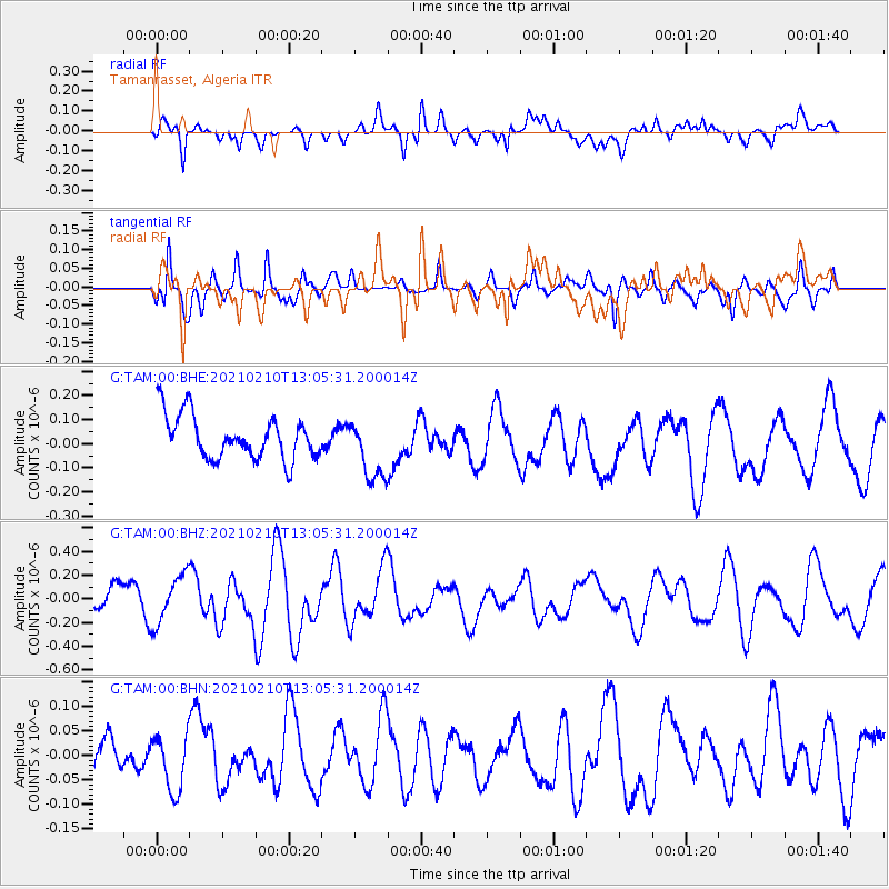
TAM Tamanrasset, Algeria - Earthquake Result Viewer
*The percent match for this event was below the threshold and hence no stack was calculated.
| Earthquake location: |
Southwest Of Sumatra, Indonesia |
| Earthquake latitude/longitude: |
-5.7/101.7 |
| Earthquake time(UTC): |
2021/02/10 (041) 12:52:27 GMT |
| Earthquake Depth: |
10 km |
| Earthquake Magnitude: |
6.2 Mww |
| Earthquake Catalog/Contributor: |
NEIC PDE/us |
|
| Network: |
G GEOSCOPE |
| Station: |
TAM Tamanrasset, Algeria |
| Lat/Lon: |
22.79 N/5.53 E |
| Elevation: |
1377 m |
|
| Distance: |
97.8 deg |
| Az: |
292.157 deg |
| Baz: |
92.868 deg |
| Ray Param: |
$rayparam |
*The percent match for this event was below the threshold and hence was not used in the summary stack. |
|
| Radial Match: |
66.04351 % |
| Radial Bump: |
400 |
| Transverse Match: |
62.939987 % |
| Transverse Bump: |
386 |
| SOD ConfigId: |
23341671 |
| Insert Time: |
2021-02-24 13:56:08.084 +0000 |
| GWidth: |
2.5 |
| Max Bumps: |
400 |
| Tol: |
0.001 |
|
Signal To Noise
| Channel | StoN | STA | LTA |
| G:TAM:00:BHZ:20210210T13:05:31.200014Z | 1.3587457 | 2.0522448E-7 | 1.5103964E-7 |
| G:TAM:00:BHN:20210210T13:05:31.200014Z | 0.6290889 | 5.593514E-8 | 8.8914526E-8 |
| G:TAM:00:BHE:20210210T13:05:31.200014Z | 1.408688 | 1.2913935E-7 | 9.167349E-8 |
| Arrivals |
| Ps | |
| PpPs | |
| PsPs/PpSs | |


