You are here: Home > Network List > GO - National Seismic Network of Georgia Stations List
> Station TBLG Delisi, Georgia > Earthquake Result Viewer
TBLG Delisi, Georgia - Earthquake Result Viewer

| Earthquake location: |
Southwest Of Sumatra, Indonesia |
| Earthquake latitude/longitude: |
-5.7/101.7 |
| Earthquake time(UTC): |
2021/02/10 (041) 12:52:27 GMT |
| Earthquake Depth: |
10 km |
| Earthquake Magnitude: |
6.2 Mww |
| Earthquake Catalog/Contributor: |
NEIC PDE/us |
|
| Network: |
GO National Seismic Network of Georgia |
| Station: |
TBLG Delisi, Georgia |
| Lat/Lon: |
41.73 N/44.74 E |
| Elevation: |
510 m |
|
| Distance: |
70.0 deg |
| Az: |
318.142 deg |
| Baz: |
117.476 deg |
| Ray Param: |
0.055269465 |
| Estimated Moho Depth: |
61.25 km |
| Estimated Crust Vp/Vs: |
1.60 |
| Assumed Crust Vp: |
6.291 km/s |
| Estimated Crust Vs: |
3.932 km/s |
| Estimated Crust Poisson's Ratio: |
0.18 |
|
| Radial Match: |
91.904015 % |
| Radial Bump: |
400 |
| Transverse Match: |
78.32321 % |
| Transverse Bump: |
400 |
| SOD ConfigId: |
23341671 |
| Insert Time: |
2021-02-24 13:56:21.671 +0000 |
| GWidth: |
2.5 |
| Max Bumps: |
400 |
| Tol: |
0.001 |
|
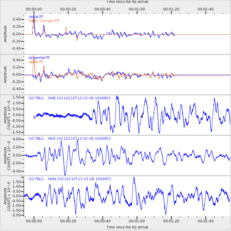
Signal To Noise
| Channel | StoN | STA | LTA |
| GO:TBLG: :HHZ:20210210T13:03:08.169985Z | 3.6419363 | 5.327884E-7 | 1.4629262E-7 |
| GO:TBLG: :HHN:20210210T13:03:08.169985Z | 1.1114587 | 2.2669606E-7 | 2.0396267E-7 |
| GO:TBLG: :HHE:20210210T13:03:08.169985Z | 2.1100981 | 2.1085283E-7 | 9.99256E-8 |
| Arrivals |
| Ps | 6.1 SECOND |
| PpPs | 24 SECOND |
| PsPs/PpSs | 30 SECOND |


