You are here: Home > Network List > IU - Global Seismograph Network (GSN - IRIS/USGS) Stations List
> Station JOHN Johnston Island, USA > Earthquake Result Viewer
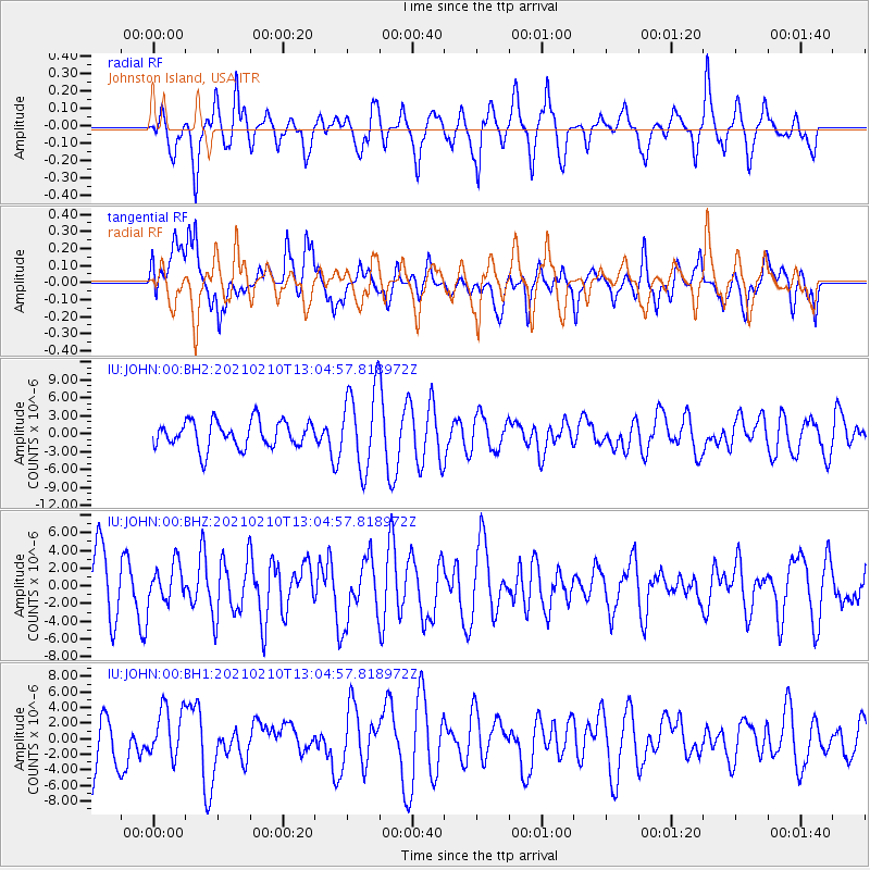
JOHN Johnston Island, USA - Earthquake Result Viewer
*The percent match for this event was below the threshold and hence no stack was calculated.
| Earthquake location: |
Southwest Of Sumatra, Indonesia |
| Earthquake latitude/longitude: |
-5.7/101.7 |
| Earthquake time(UTC): |
2021/02/10 (041) 12:52:27 GMT |
| Earthquake Depth: |
10 km |
| Earthquake Magnitude: |
6.2 Mww |
| Earthquake Catalog/Contributor: |
NEIC PDE/us |
|
| Network: |
IU Global Seismograph Network (GSN - IRIS/USGS) |
| Station: |
JOHN Johnston Island, USA |
| Lat/Lon: |
16.73 N/169.53 W |
| Elevation: |
2.0 m |
|
| Distance: |
90.5 deg |
| Az: |
73.339 deg |
| Baz: |
264.27 deg |
| Ray Param: |
$rayparam |
*The percent match for this event was below the threshold and hence was not used in the summary stack. |
|
| Radial Match: |
66.98348 % |
| Radial Bump: |
399 |
| Transverse Match: |
49.87944 % |
| Transverse Bump: |
400 |
| SOD ConfigId: |
23341671 |
| Insert Time: |
2021-02-24 13:56:56.270 +0000 |
| GWidth: |
2.5 |
| Max Bumps: |
400 |
| Tol: |
0.001 |
|
Signal To Noise
| Channel | StoN | STA | LTA |
| IU:JOHN:00:BHZ:20210210T13:04:57.818972Z | 0.85246 | 2.118193E-6 | 2.4848005E-6 |
| IU:JOHN:00:BH1:20210210T13:04:57.818972Z | 0.69988304 | 3.0813114E-6 | 4.402609E-6 |
| IU:JOHN:00:BH2:20210210T13:04:57.818972Z | 3.013976 | 6.782727E-6 | 2.2504248E-6 |
| Arrivals |
| Ps | |
| PpPs | |
| PsPs/PpSs | |


