You are here: Home > Network List > IU - Global Seismograph Network (GSN - IRIS/USGS) Stations List
> Station LSZ Lusaka, Zambia > Earthquake Result Viewer
LSZ Lusaka, Zambia - Earthquake Result Viewer
| Earthquake location: |
Southwest Of Sumatra, Indonesia |
| Earthquake latitude/longitude: |
-5.7/101.7 |
| Earthquake time(UTC): |
2021/02/10 (041) 12:52:27 GMT |
| Earthquake Depth: |
10 km |
| Earthquake Magnitude: |
6.2 Mww |
| Earthquake Catalog/Contributor: |
NEIC PDE/us |
|
| Network: |
IU Global Seismograph Network (GSN - IRIS/USGS) |
| Station: |
LSZ Lusaka, Zambia |
| Lat/Lon: |
15.28 S/28.19 E |
| Elevation: |
1200 m |
|
| Distance: |
72.6 deg |
| Az: |
255.826 deg |
| Baz: |
91.23 deg |
| Ray Param: |
0.0535636 |
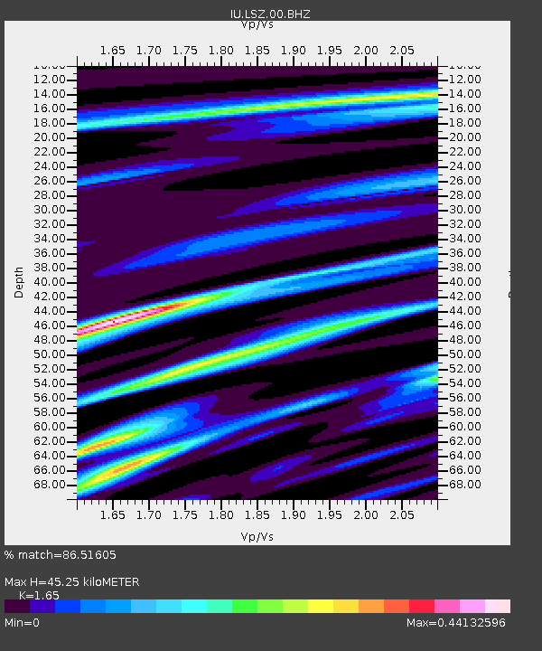
| Estimated Moho Depth: |
45.25 km |
| Estimated Crust Vp/Vs: |
1.65 |
| Assumed Crust Vp: |
6.642 km/s |
| Estimated Crust Vs: |
4.025 km/s |
| Estimated Crust Poisson's Ratio: |
0.21 |
|
| Radial Match: |
86.51605 % |
| Radial Bump: |
400 |
| Transverse Match: |
65.34606 % |
| Transverse Bump: |
400 |
| SOD ConfigId: |
23341671 |
| Insert Time: |
2021-02-24 13:57:02.295 +0000 |
| GWidth: |
2.5 |
| Max Bumps: |
400 |
| Tol: |
0.001 |
|

Signal To Noise
| Channel | StoN | STA | LTA |
| IU:LSZ:00:BHZ:20210210T13:03:23.718996Z | 2.3367379 | 4.3503667E-7 | 1.8617264E-7 |
| IU:LSZ:00:BH1:20210210T13:03:23.718996Z | 2.2750762 | 1.8820337E-7 | 8.272399E-8 |
| IU:LSZ:00:BH2:20210210T13:03:23.718996Z | 2.6470501 | 2.747981E-7 | 1.03812965E-7 |
| Arrivals |
| Ps | 4.6 SECOND |
| PpPs | 17 SECOND |
| PsPs/PpSs | 22 SECOND |


