You are here: Home > Network List > KR - Kyrgyz Digital Network Stations List
> Station ARSB Arslanbob, Kyrgyzstan > Earthquake Result Viewer
ARSB Arslanbob, Kyrgyzstan - Earthquake Result Viewer
| Earthquake location: |
Southwest Of Sumatra, Indonesia |
| Earthquake latitude/longitude: |
-5.7/101.7 |
| Earthquake time(UTC): |
2021/02/10 (041) 12:52:27 GMT |
| Earthquake Depth: |
10 km |
| Earthquake Magnitude: |
6.2 Mww |
| Earthquake Catalog/Contributor: |
NEIC PDE/us |
|
| Network: |
KR Kyrgyz Digital Network |
| Station: |
ARSB Arslanbob, Kyrgyzstan |
| Lat/Lon: |
41.33 N/72.97 E |
| Elevation: |
1378 m |
|
| Distance: |
53.6 deg |
| Az: |
333.324 deg |
| Baz: |
143.613 deg |
| Ray Param: |
0.065981545 |
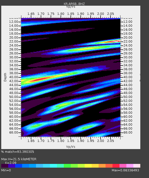
| Estimated Moho Depth: |
21.5 km |
| Estimated Crust Vp/Vs: |
2.09 |
| Assumed Crust Vp: |
6.306 km/s |
| Estimated Crust Vs: |
3.017 km/s |
| Estimated Crust Poisson's Ratio: |
0.35 |
|
| Radial Match: |
93.390305 % |
| Radial Bump: |
400 |
| Transverse Match: |
88.31094 % |
| Transverse Bump: |
400 |
| SOD ConfigId: |
23341671 |
| Insert Time: |
2021-02-24 13:57:34.131 +0000 |
| GWidth: |
2.5 |
| Max Bumps: |
400 |
| Tol: |
0.001 |
|

Signal To Noise
| Channel | StoN | STA | LTA |
| KR:ARSB: :BHZ:20210210T13:01:17.919985Z | 6.877833 | 9.688057E-7 | 1.4085914E-7 |
| KR:ARSB: :BHN:20210210T13:01:17.919985Z | 3.820234 | 3.944571E-7 | 1.0325469E-7 |
| KR:ARSB: :BHE:20210210T13:01:17.919985Z | 2.5698364 | 2.7862168E-7 | 1.0842001E-7 |
| Arrivals |
| Ps | 3.9 SECOND |
| PpPs | 10 SECOND |
| PsPs/PpSs | 14 SECOND |


