You are here: Home > Network List > KR - Kyrgyz Digital Network Stations List
> Station DRK Karamyk, Kyrgyzstan > Earthquake Result Viewer
DRK Karamyk, Kyrgyzstan - Earthquake Result Viewer
| Earthquake location: |
Southwest Of Sumatra, Indonesia |
| Earthquake latitude/longitude: |
-5.7/101.7 |
| Earthquake time(UTC): |
2021/02/10 (041) 12:52:27 GMT |
| Earthquake Depth: |
10 km |
| Earthquake Magnitude: |
6.2 Mww |
| Earthquake Catalog/Contributor: |
NEIC PDE/us |
|
| Network: |
KR Kyrgyz Digital Network |
| Station: |
DRK Karamyk, Kyrgyzstan |
| Lat/Lon: |
39.48 N/71.80 E |
| Elevation: |
2627 m |
|
| Distance: |
52.7 deg |
| Az: |
331.034 deg |
| Baz: |
141.484 deg |
| Ray Param: |
0.0665878 |
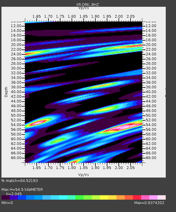
| Estimated Moho Depth: |
54.5 km |
| Estimated Crust Vp/Vs: |
2.05 |
| Assumed Crust Vp: |
6.306 km/s |
| Estimated Crust Vs: |
3.084 km/s |
| Estimated Crust Poisson's Ratio: |
0.34 |
|
| Radial Match: |
84.52193 % |
| Radial Bump: |
400 |
| Transverse Match: |
59.285957 % |
| Transverse Bump: |
400 |
| SOD ConfigId: |
23341671 |
| Insert Time: |
2021-02-24 13:57:38.655 +0000 |
| GWidth: |
2.5 |
| Max Bumps: |
400 |
| Tol: |
0.001 |
|

Signal To Noise
| Channel | StoN | STA | LTA |
| KR:DRK: :BHZ:20210210T13:01:11.219973Z | 6.7360945 | 6.712129E-7 | 9.9644225E-8 |
| KR:DRK: :BHN:20210210T13:01:11.219973Z | 0.7547944 | 3.680773E-7 | 4.876524E-7 |
| KR:DRK: :BHE:20210210T13:01:11.219973Z | 1.4198011 | 2.625391E-7 | 1.8491258E-7 |
| Arrivals |
| Ps | 9.5 SECOND |
| PpPs | 25 SECOND |
| PsPs/PpSs | 35 SECOND |


