You are here: Home > Network List > HV - Hawaiian Volcano Observatory Network Stations List
> Station MLOD Mauna Loa, Hawaii Digital > Earthquake Result Viewer
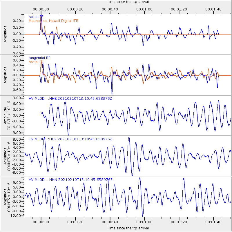
MLOD Mauna Loa, Hawaii Digital - Earthquake Result Viewer
*The percent match for this event was below the threshold and hence no stack was calculated.
| Earthquake location: |
Southeast Of Loyalty Islands |
| Earthquake latitude/longitude: |
-22.8/171.6 |
| Earthquake time(UTC): |
2021/02/10 (041) 13:02:00 GMT |
| Earthquake Depth: |
10 km |
| Earthquake Magnitude: |
6.1 Mww |
| Earthquake Catalog/Contributor: |
NEIC PDE/us |
|
| Network: |
HV Hawaiian Volcano Observatory Network |
| Station: |
MLOD Mauna Loa, Hawaii Digital |
| Lat/Lon: |
19.49 N/155.39 W |
| Elevation: |
2044 m |
|
| Distance: |
53.0 deg |
| Az: |
40.106 deg |
| Baz: |
219.066 deg |
| Ray Param: |
$rayparam |
*The percent match for this event was below the threshold and hence was not used in the summary stack. |
|
| Radial Match: |
52.24175 % |
| Radial Bump: |
400 |
| Transverse Match: |
60.01419 % |
| Transverse Bump: |
400 |
| SOD ConfigId: |
23341671 |
| Insert Time: |
2021-02-24 14:10:48.980 +0000 |
| GWidth: |
2.5 |
| Max Bumps: |
400 |
| Tol: |
0.001 |
|
Signal To Noise
| Channel | StoN | STA | LTA |
| HV:MLOD: :HHZ:20210210T13:10:45.658976Z | 1.7708895 | 5.456665E-6 | 3.0813128E-6 |
| HV:MLOD: :HHN:20210210T13:10:45.658976Z | 0.90125567 | 3.6203442E-6 | 4.0170003E-6 |
| HV:MLOD: :HHE:20210210T13:10:45.658976Z | 0.45746294 | 1.7219515E-6 | 3.7641335E-6 |
| Arrivals |
| Ps | |
| PpPs | |
| PsPs/PpSs | |


