You are here: Home > Network List > GE - GEOFON Stations List
> Station WLF GEOFON Station Walferdange, Luxembourg > Earthquake Result Viewer
WLF GEOFON Station Walferdange, Luxembourg - Earthquake Result Viewer
| Earthquake location: |
Myanmar |
| Earthquake latitude/longitude: |
20.5/94.2 |
| Earthquake time(UTC): |
1994/05/29 (149) 14:11:51 GMT |
| Earthquake Depth: |
42 km |
| Earthquake Magnitude: |
6.2 MB, 6.2 MS, 5.9 UNKNOWN, 6.5 MW |
| Earthquake Catalog/Contributor: |
WHDF/NEIC |
|
| Network: |
GE GEOFON |
| Station: |
WLF GEOFON Station Walferdange, Luxembourg |
| Lat/Lon: |
49.66 N/6.15 E |
| Elevation: |
295 m |
|
| Distance: |
73.4 deg |
| Az: |
317.33 deg |
| Baz: |
77.843 deg |
| Ray Param: |
0.05298445 |
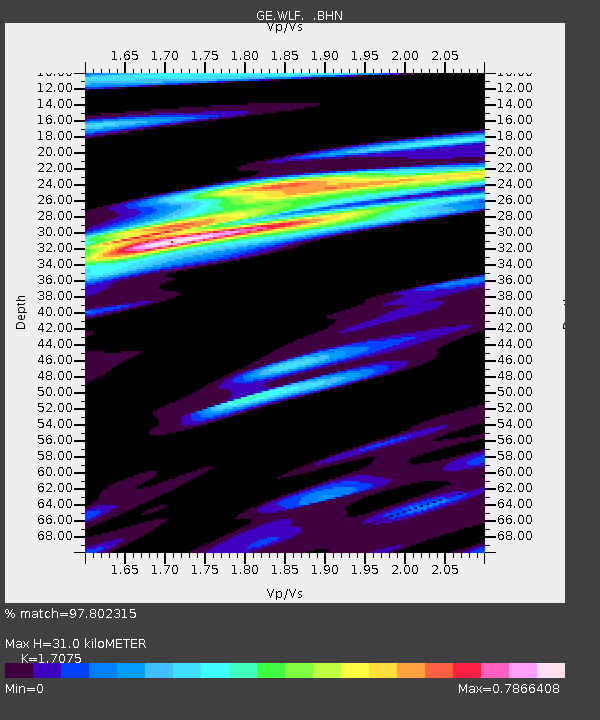
| Estimated Moho Depth: |
31.0 km |
| Estimated Crust Vp/Vs: |
1.71 |
| Assumed Crust Vp: |
6.182 km/s |
| Estimated Crust Vs: |
3.621 km/s |
| Estimated Crust Poisson's Ratio: |
0.24 |
|
| Radial Match: |
97.802315 % |
| Radial Bump: |
400 |
| Transverse Match: |
95.891815 % |
| Transverse Bump: |
400 |
| SOD ConfigId: |
16938 |
| Insert Time: |
2010-03-09 05:16:00.567 +0000 |
| GWidth: |
2.5 |
| Max Bumps: |
400 |
| Tol: |
0.001 |
|

Signal To Noise
| Channel | StoN | STA | LTA |
| GE:WLF: :BHN:19940529T14:22:48.252002Z | 1.0833523 | 1.0016229E-7 | 9.245588E-8 |
| GE:WLF: :BHE:19940529T14:22:48.252002Z | 3.2335591 | 2.2515381E-7 | 6.963034E-8 |
| GE:WLF: :BHZ:19940529T14:22:48.252002Z | 10.142064 | 6.774511E-7 | 6.679618E-8 |
| Arrivals |
| Ps | 3.7 SECOND |
| PpPs | 13 SECOND |
| PsPs/PpSs | 17 SECOND |


