You are here: Home > Network List > AK - Alaska Regional Network Stations List
> Station SII Sitkinak Island Coast Guard > Earthquake Result Viewer
SII Sitkinak Island Coast Guard - Earthquake Result Viewer
| Earthquake location: |
Southeast Of Loyalty Islands |
| Earthquake latitude/longitude: |
-23.1/171.6 |
| Earthquake time(UTC): |
2021/02/10 (041) 13:19:55 GMT |
| Earthquake Depth: |
10 km |
| Earthquake Magnitude: |
7.7 mww |
| Earthquake Catalog/Contributor: |
NEIC PDE/us |
|
| Network: |
AK Alaska Regional Network |
| Station: |
SII Sitkinak Island Coast Guard |
| Lat/Lon: |
56.56 N/154.18 W |
| Elevation: |
465 m |
|
| Distance: |
84.4 deg |
| Az: |
18.228 deg |
| Baz: |
211.359 deg |
| Ray Param: |
0.045507524 |
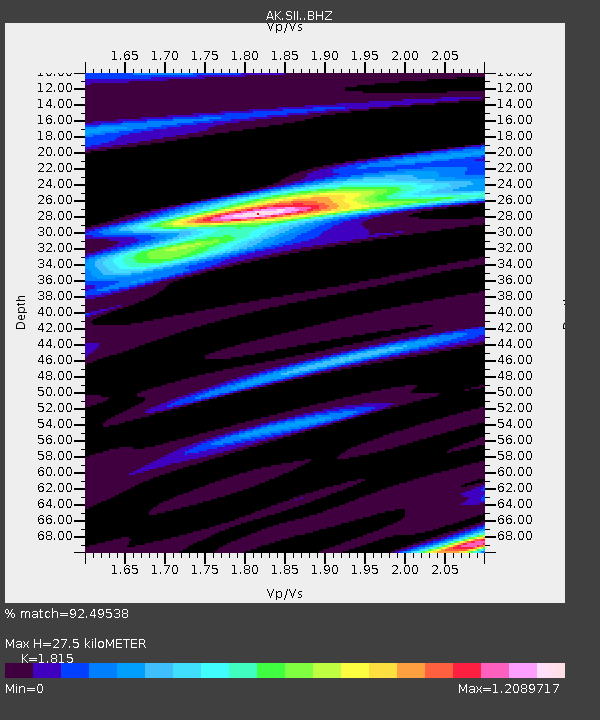
| Estimated Moho Depth: |
27.5 km |
| Estimated Crust Vp/Vs: |
1.82 |
| Assumed Crust Vp: |
6.24 km/s |
| Estimated Crust Vs: |
3.438 km/s |
| Estimated Crust Poisson's Ratio: |
0.28 |
|
| Radial Match: |
92.49538 % |
| Radial Bump: |
400 |
| Transverse Match: |
78.09812 % |
| Transverse Bump: |
400 |
| SOD ConfigId: |
23341671 |
| Insert Time: |
2021-02-24 14:22:04.482 +0000 |
| GWidth: |
2.5 |
| Max Bumps: |
400 |
| Tol: |
0.001 |
|

Signal To Noise
| Channel | StoN | STA | LTA |
| AK:SII: :BHZ:20210210T13:31:56.92801Z | 2.3479419 | 2.211751E-6 | 9.419957E-7 |
| AK:SII: :BHN:20210210T13:31:56.92801Z | 1.2075297 | 1.5551249E-6 | 1.2878564E-6 |
| AK:SII: :BHE:20210210T13:31:56.92801Z | 1.2947059 | 1.4078171E-6 | 1.0873644E-6 |
| Arrivals |
| Ps | 3.7 SECOND |
| PpPs | 12 SECOND |
| PsPs/PpSs | 16 SECOND |


