You are here: Home > Network List > AK - Alaska Regional Network Stations List
> Station K13K Kusilvak Mountain, AK, USA > Earthquake Result Viewer
K13K Kusilvak Mountain, AK, USA - Earthquake Result Viewer
| Earthquake location: |
Southeast Of Loyalty Islands |
| Earthquake latitude/longitude: |
-23.1/171.6 |
| Earthquake time(UTC): |
2021/02/10 (041) 13:19:55 GMT |
| Earthquake Depth: |
10 km |
| Earthquake Magnitude: |
7.7 mww |
| Earthquake Catalog/Contributor: |
NEIC PDE/us |
|
| Network: |
AK Alaska Regional Network |
| Station: |
K13K Kusilvak Mountain, AK, USA |
| Lat/Lon: |
61.93 N/164.66 W |
| Elevation: |
204 m |
|
| Distance: |
86.8 deg |
| Az: |
10.996 deg |
| Baz: |
201.805 deg |
| Ray Param: |
0.043785583 |
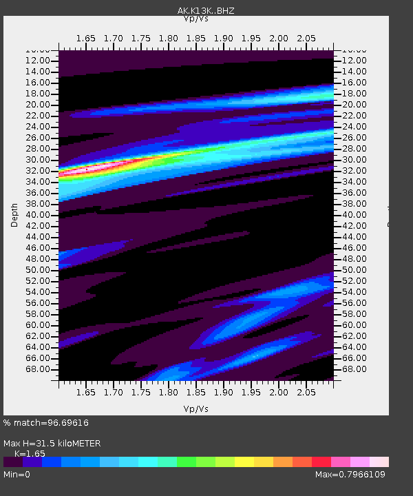
| Estimated Moho Depth: |
31.5 km |
| Estimated Crust Vp/Vs: |
1.65 |
| Assumed Crust Vp: |
6.1 km/s |
| Estimated Crust Vs: |
3.697 km/s |
| Estimated Crust Poisson's Ratio: |
0.21 |
|
| Radial Match: |
96.69616 % |
| Radial Bump: |
219 |
| Transverse Match: |
82.03882 % |
| Transverse Bump: |
400 |
| SOD ConfigId: |
23341671 |
| Insert Time: |
2021-02-24 14:22:34.166 +0000 |
| GWidth: |
2.5 |
| Max Bumps: |
400 |
| Tol: |
0.001 |
|

Signal To Noise
| Channel | StoN | STA | LTA |
| AK:K13K: :BHZ:20210210T13:32:08.819978Z | 2.6354396 | 1.0454066E-6 | 3.966726E-7 |
| AK:K13K: :BHN:20210210T13:32:08.819978Z | 1.7511894 | 5.999737E-7 | 3.4260927E-7 |
| AK:K13K: :BHE:20210210T13:32:08.819978Z | 0.7238492 | 3.5290864E-7 | 4.875444E-7 |
| Arrivals |
| Ps | 3.4 SECOND |
| PpPs | 13 SECOND |
| PsPs/PpSs | 17 SECOND |


