You are here: Home > Network List > IU - Global Seismograph Network (GSN - IRIS/USGS) Stations List
> Station SFJD Sondre Stromfjord, Greenland > Earthquake Result Viewer
SFJD Sondre Stromfjord, Greenland - Earthquake Result Viewer
| Earthquake location: |
Rat Islands, Aleutian Islands |
| Earthquake latitude/longitude: |
52.4/176.8 |
| Earthquake time(UTC): |
2017/10/08 (281) 22:34:33 GMT |
| Earthquake Depth: |
112 km |
| Earthquake Magnitude: |
6.6 mww |
| Earthquake Catalog/Contributor: |
NEIC PDE/us |
|
| Network: |
IU Global Seismograph Network (GSN - IRIS/USGS) |
| Station: |
SFJD Sondre Stromfjord, Greenland |
| Lat/Lon: |
67.00 N/50.62 W |
| Elevation: |
330 m |
|
| Distance: |
55.6 deg |
| Az: |
20.526 deg |
| Baz: |
326.905 deg |
| Ray Param: |
0.06432085 |
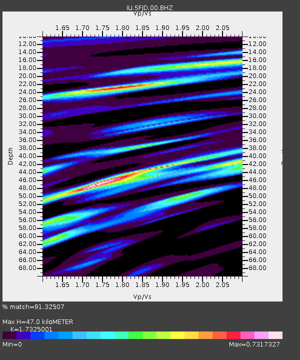
| Estimated Moho Depth: |
47.0 km |
| Estimated Crust Vp/Vs: |
1.73 |
| Assumed Crust Vp: |
6.459 km/s |
| Estimated Crust Vs: |
3.728 km/s |
| Estimated Crust Poisson's Ratio: |
0.25 |
|
| Radial Match: |
91.32507 % |
| Radial Bump: |
376 |
| Transverse Match: |
68.18953 % |
| Transverse Bump: |
311 |
| SOD ConfigId: |
2364251 |
| Insert Time: |
2017-10-22 22:44:57.325 +0000 |
| GWidth: |
2.5 |
| Max Bumps: |
400 |
| Tol: |
0.001 |
|
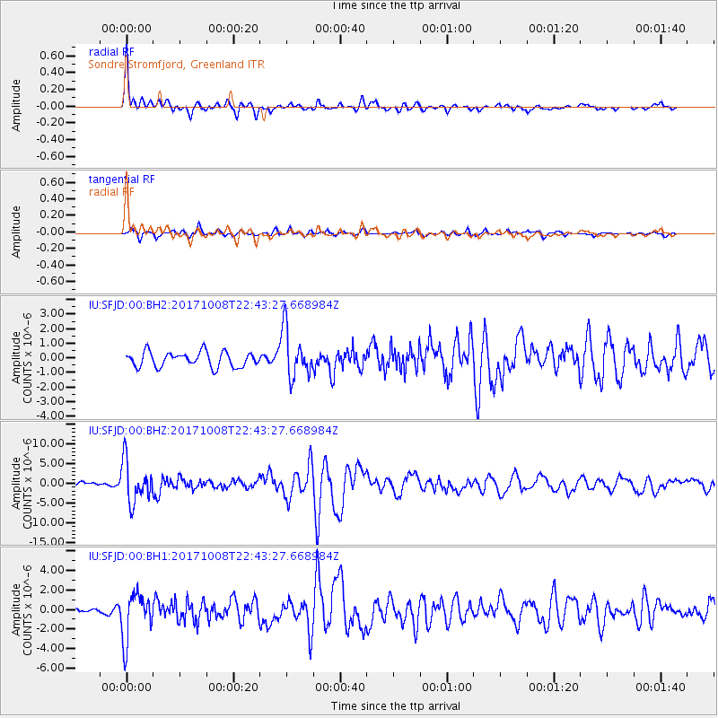
Signal To Noise
| Channel | StoN | STA | LTA |
| IU:SFJD:00:BHZ:20171008T22:43:27.668984Z | 8.684056 | 5.25587E-6 | 6.052321E-7 |
| IU:SFJD:00:BH1:20171008T22:43:27.668984Z | 8.937913 | 2.410497E-6 | 2.696935E-7 |
| IU:SFJD:00:BH2:20171008T22:43:27.668984Z | 3.2203307 | 1.6419668E-6 | 5.0987524E-7 |
| Arrivals |
| Ps | 5.6 SECOND |
| PpPs | 19 SECOND |
| PsPs/PpSs | 24 SECOND |


