You are here: Home > Network List > AZ - ANZA Regional Network Stations List
> Station SMER AZ.SMER > Earthquake Result Viewer
SMER AZ.SMER - Earthquake Result Viewer
| Earthquake location: |
Southeast Of Loyalty Islands |
| Earthquake latitude/longitude: |
-23.1/171.6 |
| Earthquake time(UTC): |
2021/02/10 (041) 13:19:55 GMT |
| Earthquake Depth: |
10 km |
| Earthquake Magnitude: |
7.7 mww |
| Earthquake Catalog/Contributor: |
NEIC PDE/us |
|
| Network: |
AZ ANZA Regional Network |
| Station: |
SMER AZ.SMER |
| Lat/Lon: |
33.46 N/117.17 W |
| Elevation: |
355 m |
|
| Distance: |
88.0 deg |
| Az: |
52.371 deg |
| Baz: |
240.761 deg |
| Ray Param: |
0.0428817 |
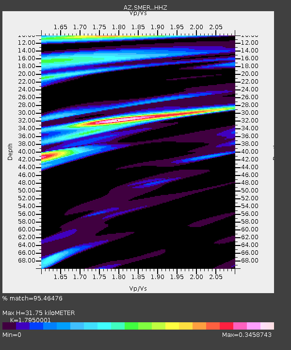
| Estimated Moho Depth: |
31.75 km |
| Estimated Crust Vp/Vs: |
1.80 |
| Assumed Crust Vp: |
6.264 km/s |
| Estimated Crust Vs: |
3.489 km/s |
| Estimated Crust Poisson's Ratio: |
0.27 |
|
| Radial Match: |
95.46476 % |
| Radial Bump: |
252 |
| Transverse Match: |
89.944016 % |
| Transverse Bump: |
339 |
| SOD ConfigId: |
23341671 |
| Insert Time: |
2021-02-24 14:24:31.196 +0000 |
| GWidth: |
2.5 |
| Max Bumps: |
400 |
| Tol: |
0.001 |
|
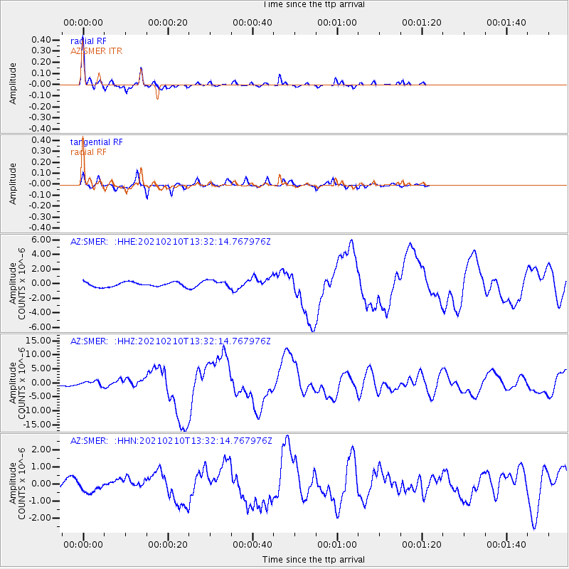
Signal To Noise
| Channel | StoN | STA | LTA |
| AZ:SMER: :HHZ:20210210T13:32:14.767976Z | 2.163055 | 8.5217846E-7 | 3.9396986E-7 |
| AZ:SMER: :HHN:20210210T13:32:14.767976Z | 1.4072894 | 3.0611457E-7 | 2.1752071E-7 |
| AZ:SMER: :HHE:20210210T13:32:14.767976Z | 1.5348283 | 4.7660825E-7 | 3.105287E-7 |
| Arrivals |
| Ps | 4.1 SECOND |
| PpPs | 14 SECOND |
| PsPs/PpSs | 18 SECOND |


