You are here: Home > Network List > C1 - Red Sismologica Nacional Stations List
> Station MT09 Talagante > Earthquake Result Viewer
MT09 Talagante - Earthquake Result Viewer
| Earthquake location: |
Southeast Of Loyalty Islands |
| Earthquake latitude/longitude: |
-23.1/171.6 |
| Earthquake time(UTC): |
2021/02/10 (041) 13:19:55 GMT |
| Earthquake Depth: |
10 km |
| Earthquake Magnitude: |
7.7 mww |
| Earthquake Catalog/Contributor: |
NEIC PDE/us |
|
| Network: |
C1 Red Sismologica Nacional |
| Station: |
MT09 Talagante |
| Lat/Lon: |
33.78 S/70.99 W |
| Elevation: |
1371 m |
|
| Distance: |
97.9 deg |
| Az: |
131.709 deg |
| Baz: |
235.643 deg |
| Ray Param: |
0.0400685 |
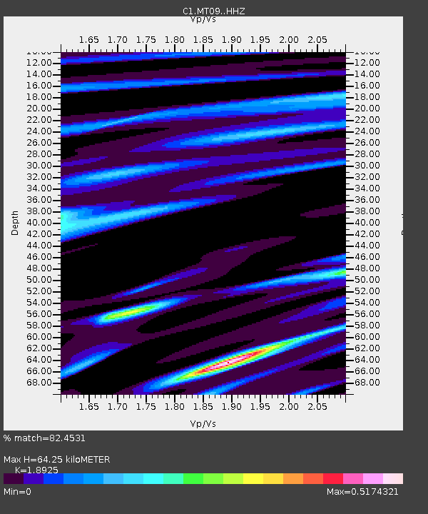
| Estimated Moho Depth: |
64.25 km |
| Estimated Crust Vp/Vs: |
1.89 |
| Assumed Crust Vp: |
6.481 km/s |
| Estimated Crust Vs: |
3.424 km/s |
| Estimated Crust Poisson's Ratio: |
0.31 |
|
| Radial Match: |
82.4531 % |
| Radial Bump: |
400 |
| Transverse Match: |
71.82541 % |
| Transverse Bump: |
400 |
| SOD ConfigId: |
23341671 |
| Insert Time: |
2021-02-24 14:25:26.471 +0000 |
| GWidth: |
2.5 |
| Max Bumps: |
400 |
| Tol: |
0.001 |
|

Signal To Noise
| Channel | StoN | STA | LTA |
| C1:MT09: :HHZ:20210210T13:32:59.998994Z | 1.9930267 | 5.0591177E-7 | 2.5384094E-7 |
| C1:MT09: :HHN:20210210T13:32:59.998994Z | 0.62242 | 2.1718444E-7 | 3.4893552E-7 |
| C1:MT09: :HHE:20210210T13:32:59.998994Z | 2.675283 | 6.611321E-7 | 2.4712605E-7 |
| Arrivals |
| Ps | 9.0 SECOND |
| PpPs | 28 SECOND |
| PsPs/PpSs | 37 SECOND |


